


3853 Atlantic Ave.

|
Click here |
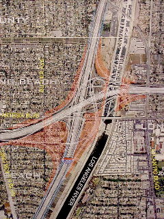
Digital Maps Showing Impacts Of 710 Fwy. Expansion Options Posted By Gateway Cities Council Of Gov'ts; LBReport.com Links To Them
To access the maps, click the thumbnail size photo (right). The maps were shared quietly with local officialdom and kept under wraps until revealed in articles by Los Angeles Times reporter Deborah Schoch. Ms. Schoch described potential neighborhood impacts and closed door decisionmaking in painful detail, scooping LB media and prompting neighborhood calls to see the maps.
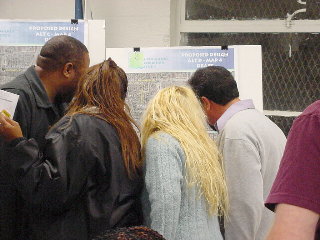
Gateway Cities responded by bringing oversize versions of the maps -- mounted on easels -- to some of their meetings...and continued to insist that the public attend Gateway Cities' meetings or come to Gateway Cities' HQ (or MTA HQ) to see the maps.
On April 11, LBReport.com made a request under state freedom of information law (the CA Public Records Act) to the Gateway Cities Council of Governments, seeking access to digital versions of the maps. (We reasoned that the maps shown on the easels almost certainly had been produced on a computer...and thus were in digital form.)
On April 21, the Gateway Cities Council of Governments responded that "the MTA should have access to the maps in digital or electronic format." On April 22, we contacted MTA and learned the maps were, in fact, in the process of being posted on the internet. By late afternoon April 22, a number of the maps had appeared on the Gateway Cities' web site, with assurances that the remainder were forthcoming.
The maps are preceded by the following disclaimer:
The maps are large files, roughly between 1.5-2.0 MB...and on our 56k modem (connected at 48k) and 900 MHz computer, they took roughly seven minutes to download.
To view the maps, click on Maps Indicating 710 Freeway Expansion Options.
Placing the maps on the internet makes them far more accessible to the general public, available in peoples' homes and at neighborhood libraries.
On April 28, as previously reported by LBReport.com, a "Community Open House" on the 710 freeway expansion project will take place between 6:00-8:00 p.m. (arrive any time during this period) at the LB Main Library, 101 Pacific Ave.
A flier states, "Come learn what improvements are being planned for the I-710 Corridor. Some of these improvements include widening of I-710, redesign and reconstruction of freeway interchanges. We want to hear your suggestions and comments...Each open house will have experts available to answer your questions. There will be no formal presentation..."
The Gateway Cities Council of Governments is the lead agency for the 710 Major Corridor Study (undertaken jointly by the Gateway group, L.A. County Metropolitan Transportation Authority, Caltrans and So. Cal. Ass'n of Governments).
The President of the Board of Directors of the Gateway Cities Council of Governments is LB Vice Mayor Frank Colonna...who also heads the group's I-710 Oversight Committee. He also serves on the group's Executive Committee. LB Mayor Beverly O'Neill also holds a seat on the Executive Committee, which she has delegated to 1st district Councilwoman Bonnie Lowenthal.
The City of Long Beach and the Port of Long Beach are both member entities of the Gateway Cities Council of Governments. The Gateway group's Executive Committee includes Vice Mayor Colonna...who is also on the Gateway Council's I-710 Oversight Policy Committee which will make final decisions regarding the study.
|
 Previously, the public had to come to Gateway Cities meetings to see the maps. On April 16,