


3853 Atlantic Ave.

|
Click here |
Latest State Map Shows LB & Much Of L.A. With
(April 23, 2003) -- The CA Seismic Safety Commission has released a map showing what it considers earthquake shaking and damage potential for CA.
The So. Cal area excerpted by us (below) shows the LA-LB area with 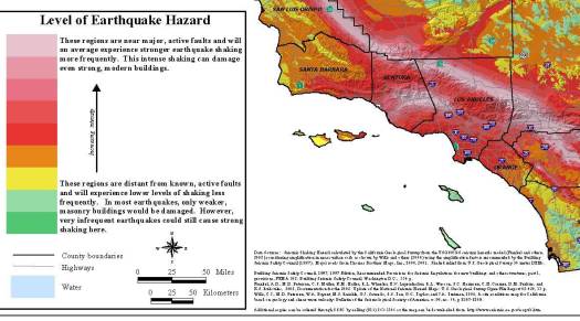 The statewide map is available in larger, more detailed form...and LBReport.com posts the links to it from the CA Seismic Safety Comm'n web site in both .jpg and .pdf formats on links below. Caveat: They're large files and may take a few minutes to download via modem. Tip: The pdf file is a large file but lets you to magnify small areas. The CA Seismic Safety Commission says the map "shows the relative intensity of ground shaking and damage in CA from anticipated future earthquakes. Although the greatest hazard is in the areas of highest intensity as shown on the map, no region within the state is immune from potential for earthquake damage." |