'
Neighborhood Groups/Individual Residents Testify Against Proposed Increased Density/Increased Height Maps; Planning Comm'n Votes (4-1) To Recommend Sending Maps Back To Staff For Add'l Public Input *BUT* City Mgm't Says It Will Send Maps To Council On <nobr>Oct. 3</nobr> For Approval (With Or Without Council-Desired Map Changes) To Proceed With Land Use Changes</a>
LBReport.com
News
Neighborhood Groups/Individual Residents Testify Against Proposed Increased Density/Increased Height Maps; Planning Comm'n Votes (4-1) To Recommend Sending Maps Back To Staff For Add'l Public Input *BUT* City Mgm't Says It Will Send Maps To Council On Oct. 3 For Approval (With Or Without Council-Desired Map Changes) To Proceed With Land Use Changes
Development Services Dir. Bodek says Council item is already scheduled for Oct. 3
LBREPORT.com is reader and advertiser supported. Support independent news in LB similar to the way people support NPR and PBS stations. We're not non-profit so it's not tax deductible but $49.95 (less than an annual dollar a week) helps keep us online.
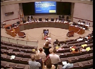
(Aug. 18, 2017, 8:35 a.m.)-- As seen LIVE on LBREPORT.com, 29 of 30 speakers from areas spanning multiple LB neighborhoods testified in opposition to city-staff proposed maps that would allow increased density and building heights in areas citywide.
At the conclusion of a nearly two hour, forty minute agenda item, the Planning Commission approved a motion (by Van Horik, seconded by (4-1, Cruz dissenting; Christoffels and Verduzco-VegaEric absent for entire meeting) to recommend that the maps be sent back to city staff for extensive stakeholder engagement with the neighborhood organizations...although city staff announced that it plans to bring its maps to the City Council on Oct 3 regardless of the Planning Commission's voted action.
[Scroll down for further.]
The public turnout was noteworthy on twp hrpimds ground: (1) neighborhood groups from various parts of the city, spanning WLB to ELB and into Cal Hts. were united in their opposition to advancing the proosed action; and (2) to our knowledge, LBREPORT.com was the only LB news outlet that previewed the Aug. 17 Planning Commission agenda item in detail (showing neighborhood impacts) and word apparently spread organically (with or without LBREPORT.com) via NextDoor, Facebook, a mass emailing to neighborhood groups from CONO leader Robert Fox and in one-on-one neighborhood contacts.
At the start of city staff's presentation, Advance Planning Officer Christopher Koontz indicated that proposed maps are "tentatively" set for Oct. 3 Council consideration, but with a Commission motion pending that recommended NOT sending the maps to the City Council without additional public outreach, Director of Development Services Amy Bodek said city staff plans to bring the proposed maps to the Council on Oct. 3 regardless of how the Planning Commission voted.
The Oct. 3 Council session would effectively amount to tentative approval, but not binding or legally conclusive approval of the proposed land use density and building heights increases, subject only to a future Planning Commission recommendation and City Council voted approval of an accompanying program EIR, the density/height increase maps and accompanying land use plan text now on track to occur early in 2018.
Sponsor
Sponsor
Of thirty speakers, twenty-nine testified in opposition. They included representatives of the Council of Neighborhood Organizations (CONO), Citizens About Responsible Planning (CARP), the Los Altos Center Adjacent Neighborhood Group, Citizens for Fair Development, the Wrigley Area Neighborhood Alliance, the Cal Hts Neighborhood Association and the Midtown Neighborhood Association. Written testimony in opposition was submitted prior to the meeting by retired 8th district Councilwoman Rae Gabelich.
In city staff's opening presentation, Advance Planning Officer Christopher Koontz urged the Planning Commission to view the proposed density increase maps in the context of what Long Beach could look like in ten or twenty years from now, with LB residents walking to work or using transit or bicycles instead of vehicles. He said city staff's plan "accommodates the changes in growth we know that we will see over the next two decades. It does so sustainably and within many legal, practical, physical and economic constraints...We feel that it provides a bold and positive vision of moving the city forward and meeting the mandates not only of the law but the mandates we receive from all of you and the City Council to enhance the city's economic position, to think about all members of society and all of our residents and provide them enhanced housing choices and to embrace the future in a sustainable way."
And Mr. Koontz added, "This item is tentatively scheduled before City Council on October 3." Mr. Koontz said that on Oct. 3, the Council could make changes to the maps that it may consider appropriate, and based on what the Council approves, city staff will update a draft EIR, recirculate it for public comments, and the EIR and its accompanying maps will then return to Planning Commission for a vote, followed by a final Council vote to certify the EIR and approve the maps.
Sponsor
Public speakers criticized the proposed density and height increases on various grounds. Several said public outreach had been negligible and/or ineffective. Others chided Mr. Koontz for proposing that the Commission vote on an imagined future that they said conflicts with present day realities...and said the Planning Commission has a responsibility to address issues that residents experience now.
At some points, speakers suggested the proposed density/height increases could bring election cycle action against Council incumbents who supported it. Fifth Council district resident Corliss Lee, who dueled at a public meeting in late May with 5th district Council incumbent Stacy Mungo (when Mungo denied and disputed Ms. Lee's accurate statements about the maps' proposed impacts on ELB) issued a press release earlier in the day indicating that residents from a number of neighborhoods are considering taking the unprecedented action of fielding a slate of reform-minded candidates citywide to challenge and replace Council incumbents on the land use issue and others in the upcoming 2018 election cycle. Another 5th district resident said a new neighborhood group is forming that would span the 5th and 4th districts, and possibly parts of the 3rd sparked by strong opposition to the proposed density and height increases.
Others speakers charged that the proposed increased density and heights amount to a City Hall sell-out to development interests, a repeat of now-discredited 1980's Council actions that enabled "crackerbox" apartment density (and resulted in chronic parking problems for impacted neighborhoods.)
Sponsor
Sponsor
Capping the more than two and a half hour agenda item, Planning Commissioner Andy Perez said he didn't consider the density/height increase maps ready to go to the City Council and made a motion to send the maps back to city staff for more robust public outreach. "My motion is to recommend that we send this back to staff for further extensive stakeholder engagement with the neighborhood organizations to improve the land use document and to preserve the integrity of the neighborhoods and communities," Commissioner Perez said...and Commissioner Templin seconded his motion.
In response, city management's Dir. of Development Services, Amy Bodek, said the issue is already scheduled for the Oct; 3 City Council meeting (and didn't say "tentatively scheduled" as Mr. Koontz had said earlier in the meeting.) Ms. Bodek said city staff plans to bring its proposed density/height increase maps to the Council for its consideration on October 3 regardless of what the Commission recommends. Staff said that would enable preparation of a revised program EIR to proceed into the final steps of the land use change process (recirculating the program EIR, followed by Planning Commission and City Council votes on final approval).
Commission discussion followed, and Commissioner Perez reiterated his motion. It carried 4-1 (with two Planning Commission members absent for the entire meeting.)
Following the Commission vote, Advance Planning Officer Christopher Koontz said city staff now plans to communicate to the City Council that "the Commission has declined to make a recommendation to the City Council and what they are recommending is that the process not move forward but rather that there be additional public outreach. That'll be transmitted in the staff report to the City Council. This item is already scheduled before City Council for Oct. 3. At that time, the City Council will give us additional direction. At such time as an EIR has been prepared, circulated publicly and responses to comments have been prepared, it will return to this body with the accompanying text and maps for you to fulfill your role under the Public Resources Code. After that action, whatever recommendation is made by this body will be transmitted back to the City Council and the City Council is the final decision maker on this matter."
Dark purple areas on the maps allow "mixed uses" combining commercial with residential uses. Red areas are purely commercial. (A detailed map legend accompanying the maps can be viewed here.)
Sponsor
The Planning Commission action on the maps came after it voted, with some audible misgivings, to approve a seven-story multi-family residential building with 77 dwelling units and a 105-parking stall garage at 320 Alamitos Ave. (roughly ten more parking spaces than minimally required under the Council's "Downtown Plan.") The proposed Alamitos Ave. project generated intense and well-organized neighborhood opposition from residents of already-parking impacted Alamitos Beach neighborhood, who now cite the "Downtown Plan" as adding to their parking problems.
A previous Council approved the Downtown Plan in Jan. 2012 (with support then-downtown Council reps Suja Lowenthal and Robert Garcia.) It allows and invites increased density and higher building heights with less parking than City Hall previously required, and simultaneously makes it harder for residents to challenge individual project they arise because the Council approved a "program EIR," a special type of EIR that states the Council has already considered all significant environmental impacts of a land use plan for all future projects and considers them acceptable.
At one point, Planning Commission chair Donita Van Horik (scheduled to exit the Planning Commission in October to be replaced by Garcia-appointee Josh LaFarga, now the subject of opposition by CONO, CARP and others) asked city staff if the downtown plan could be changed. City staff replied yes, but said it would require a zoning amendment and city staff would oppose the action.
City staff plans to use a program EIR to accompany its now-advancing increased density/increased height land use maps.
 (Aug. 18, 2017, 8:35 a.m.)-- As seen LIVE on LBREPORT.com, 29 of 30 speakers from areas spanning multiple LB neighborhoods testified in opposition to city-staff proposed maps that would allow increased density and building heights in areas citywide.