|
News in Depth How LB City Hall Invited Vibration-Inducing Tests Into LB Neighborhoods To Find Underground Oil
(January 12, 2006, updated with color-coded map Jan. 13) -- On November 23, 2004, an item appeared on the LB City Council consent calendar (where items are approved without discussion unless requested by a Councilmember or member of the public), seeking Council approval for a five year agreement between Signal Hill Petroleum, Inc. and LB City Hall involving mineral interests.
LB octogenarian and veteran Council communicator Thomas Murphy pulled the item for discussion, read aloud an accompanying city management memo. .and drew no response from Councilmembers. LBReport.com noticed the item but didn't grasp its significance and didn't report the story.
The memo from City Hall Director of Oil Properties, Chris Garner, stated:
Signal Hill Petroleum, Inc., (SHPI) is the operator of three waterflood oil recovery Units in the Long Beach Oil Field adjacent to the Long Beach Airport. SHPI desires to collect technically advanced geological information in the Long Beach Oil Field by conducting a three-dimensional (3D) seismic survey. The new geological information will be used to improve both the waterflooding operations and the ultimate oil recovery from the field. While the seismic equipment is onsite, SHPI is interested in expanding the survey area
beyond the limit of the Long Beach Oil Field and into areas where the City owns the mineral
fee interests in anticipation of finding additional oil reserves to develop.
SHPI is proposing to lease approximately 1,100 acres of City mineral-fee property adjoining
the Long Beach Oil Field to conduct the survey. The lease rate offered to the City is $15
per acre per year for a minimum of five years with no right to surface entry. Should the
survey result in commercial production of mineral resources in the leased acreage, the City
would receive a one-sixth royalty of gross revenues, which is the industry standard...
FISCAL IMPACT
The rental fee would generate approximately $15,000 per year to the Upland Oil Fund (SR
134) for the next five years. If mineral resources were commercially developed by SHPI,
the Upland Oil Fund would realize unanticipated additional revenues through well permits,
barrel tax, and royalties.
Roughly ten months later on September 13, 2005, the Council received an update and informational report from city management on the next step. The item was on the regular agenda, drawing no Council or public comment. Again, its significance escaped our attention.
This management memo didn't seek Council approval (the Council had already authorized a contract with the firm in Nov. 2004) but management's memo for the first time described what the 3D "seismic survey" was supposed to be. The memo indicated the testing would be conducted in parts of LB (including parts of ELB), Signal Hill and Lakewood and stated:
"The exploration of oil and gas involves the evaluation of a variety of types of information...A 3D seismic survey is a method that allows the creation of images of the subsurface geology by inducing an acoustic wave from near the surface of the
earth and listening for the echoes from deeper parts of the earth (much like ultra-
sound is used to create pictures of unborn babies in their mother�s wombs). The
images from a 3D seismic survey can help geologists and engineers not only
improve the selections of future oil well locations, but also obtain new and
valuable information about fault lines."
The memo continued:
| Signal Hill Petroleum, Inc. (SHPI) has contracted with Dawson Geophysical (Dawson) and Ameridian Technologies (Ameridian) to perform a 3D seismic survey through much of Long Beach, all of Signal Hill and in some parts of Lakewood (a map is attached) [right] | 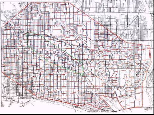
The map's color coding is explained in memo text below. For a larger and clearer pdf image of the map, click picture. Caveat: the pdf map is a large file (5.2 MB) and may require a longer than usual download. |
This survey will take approximately two months to complete. It will be conducted during daylight hours in residential areas and may also be conducted during the evening in non-residential areas. The survey will be coordinated with the Department of Parks, Recreation, and Marine - Bureau of Special Events and Filming to minimize any congestion impacts near
high traffic areas.
The method that will be used in obtaining the 3D seismic survey is used
worldwide and was devised specifically for use in urban environments to
minimize disturbance to the immediate surroundings. This testing can be
performed on both soft grounds and on pavements. It consists of a line of
specialized vibrator trucks, each containing a base plate that sends sound waves
deep into the earth. At each location marked in red on the attached map, three
or four vibrator trucks will occupy the location for less than ten minutes at a time
and then move on to the next location. While virtually all of the sound waves are
directed deep into the earth, a very minor surface vibration is also generated in
the immediate vicinity of the trucks. This vibration will dissipate to a "zero level"
very quickly as it travels away from the trucks. Dawson will monitor this ground
vibration with portable seismograph units, which will confirm this temporary minor
vibration is well within safe, acceptable limits. The monitoring will be performed
at various distances from the trucks, and adjacent to any nearby buildings. A
permanent record of these readings is archived for future reference. Along with
the vibrator trucks, there will be cabling and sensors located in various areas
(marked in blue on the attached map) to receive the information for later
processing. The sensors are small devices, slightly larger than a lawn sprinkler.
Both the sensors and the cables may stay at each location up to four weeks.
The residences and businesses located close to the intended sites of the vibrator
trucks will be contacted by Ameridian and offered a free inspection of their
property before and after the seismic survey to verify that the survey has not
impacted the existing infrastructure.
Valuable information about the oil and gas potential within the City of Long Beach
will be obtained from this survey and provided to the Department of Oil
Properties, including information that has never before been available. Other
beneficiaries to this work will include California State University, Long Beach;
University of California, Santa Barbara, and the Southern California Earthquake
Center, all who will use the information to explore potential problems with area
earthquake faults. The individual mineral rights owners in Long Beach (including
the City of Long Beach itself) and Signal Hill will also benefit.
This item was reviewed by Deputy City Attorney Charles Parkin on August 19,
2005 and Budget Management Officer David Wodynski on August 26,2005.
TIMING CONSIDERATIONS
City Council action on this matter is not time critical.
FISCAL IMPACT
The City Council approved an agreement between SHPI and the City on
November 23, 2004, for leasing of the City�s mineral interests near and under the
Airport. SHPI will pay the City to hold the mineral leases for five years and
during that time the 3D seismic survey will be conducted and processed with
hopes of new oil and gas prospects being found and developed. The lease fee
will generate approximately $15,000 per year to the Upland Oil Fund (SR 134)
through the end of the lease term. If mineral resources are commercially
developed by SHPI, the Upland Oil Fund would realize unanticipated additional
revenues through royalties and the General Fund could realize unanticipated
additional revenues through barrel taxes and well permit fees.
SUGGESTED ACTION:
Approve recommendation.
Respectfully submitted,
CHRISTOPHER J. GARNER
DIRECTOR OF LONG BEACH ENERGY & OIL PROPERTIES
APPROVED:
GERALD R. MILLER
CITY MANAGER
As posted on City Hall's website, city management's map wasn't in color, making it hard to discern what parts of LB, Signal Hill and Lakewood would receive "a line of specialized vibrator trucks" that would generate "a very minor surface vibration" and which areas would receive sensing units to record the vibrations.
[Jan. 13 update] LBReport.com has obtained a color-coded version of the map from the City Clerk's office, and we've posted the color coded map in pdf form. Because the pdf file contains colors, it's a large file (5.2 MB) and may require a longer than usual download. [end update]
Over the weekend of January 7-8, 2006, the vibration-inducing trucks appeared in LB's Wrigley area. A number of residents who experienced the vibrations came away alarmed and incensed...generating multiple complaints to City Hall and prompting city staff to look into the matter. By Tuesday January 10, city management had revoked -- for the moment -- permits granted for the testing pending discussion with the firms. That left Signal Hill Petroleum with the option of discussing the matter with city staff...or appealing the permit revocation to the City Council.
On January 17, 2006, city management has agendized an item described as "receive and file the presentation relating to Geophysical Survey by Signal Hill Petroleum -- Update by Christopher Garner."
A city management memo accompanying the agenda item wasn't immediately posted online; a placeholder indicates it will be distributed when available.
Developing.
Return To Front Page
Contact us: mail@LBReport.com
|