FURTHER UPDATE: Winds Knock Out Power To (8 p.m. hour update) 12,170 SCE Customers In These LB Zipcodes; We Unofficially Estimate It's Over 25,000 LB Residents; Plus: 2,219 Customers In 90740 Seal Beach Without Power (Likely About 20% Of Their City Population); Trees & Power Lines Down, High Wind Warning Thru Tonight
Rain Fizzles At Roughly 0.31"
LBREPORT.com is reader and advertiser supported. Support independent news in LB similar to the way people support NPR and PBS stations. We're not non-profit so it's not tax deductible but $49.95 (less than an annual dollar a week) helps keep us online.
(Jan. 31, 2016, 8:40 p.m. update) -- Continuing coverage: In the 8:00 p.m. hour, SCE's website indicates power is out [we presume for wind related reasons] to 12,170 SCE customers in Long Beach...and since an SCE customer is a metered account, we unofficially estimate the number of LB residents impacted (since families usually have 2+ people) is probably over 25,000.
SCE's wesbite indicates they're in these zipcodes:
90803: 915
90804: 945
90804: 16
90813: 1802
90813: 1253
90813: 1067
90813: 18
90806: 798
90806: 2780
90806: 1097
90806: 1007
90805: 198
90805: 42
90805: 37
90805: 195
Total: 12,170
SCE says an outage in 90740 (Seal Beach) affects 2,219 customers, which we roughly estimate (families with 2+ people) is probably more than 4,500 people. Seal Beach's population is roughly 24,000 people. On that basis, we unofficially and roughly estimate that 18-20% or more of Seal Beach's population is affected.
90740
[Scroll down for further.]
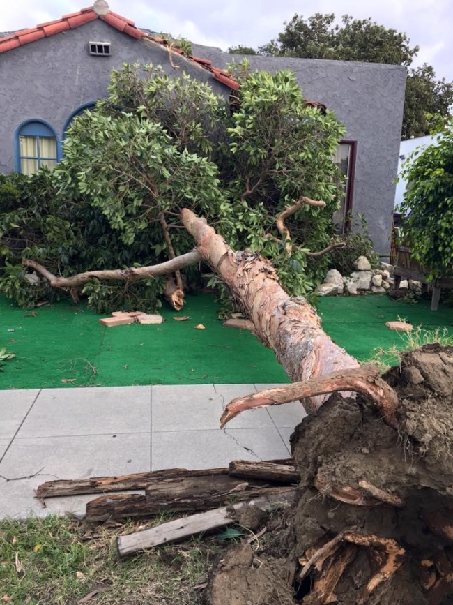
56th St./Myrtle Ave, North Long Beach. Photo via Marriem Seiuli
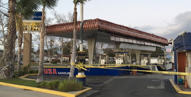
Woodruff/Los Coyotes, photo by Derek
Prices weren't the only thing falling at this gasoline station (Woodruff @ Los Coyotes.)
Woodruff/Los Coyotes, photo by Derek
The Nat'l Weather Service monitor at LB Airport recorded mile-per-hour wind speeds in the teens, gusting into the 20s starting shortly before 10 a.m. building to steady winds in the 20s with gusts into the 30s in the 2 p.m. hour. The 50 mph gust was recorded at 2:29 p.m. a bit NE of the Airport at the LBCC ELB weather station.
Advertisement
Advertisement
(Jan. 31, 2016, updated 6:05 p.m.) -- SCE has confirmed on its website that power is out in part of 90803, began at 1:35 p.m., as of 5:35 p.m., 915 SCE customers (accounts) are affected, meaning the total number of people (familymembers) may be over 2,000. [LBREPORT.com has received reader reports of the location; we won't be more specific than SCE until power is restored...but we're on the story.]
The situation is considerably worse a bit south: SCE says Seal Beach zip 90740 has 2,219 customers without power (probably over 4,000 people) as of 3:56 p.m.
(Jan. 31, 2016) -- Wind gusts into the 30 mph range -- at one point gusting to 50 mph recorded at LBCC's ELB weather station -- downed trees and knocked out power in parts of Long Beach today (Sun. Jan. 31).
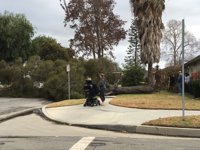
Trees are down in several areas...and power line wires are also down in several locations [use caution, some streets blocked off and power out.]
The National Weather Service has issued a continuing high wind warning through tonight:
[Nat'l Weather Service always sends its text in "all caps"] HIGH WIND WARNING REMAINS IN EFFECT UNTIL 9 PM PST THIS EVENING......WIND ADVISORY REMAINS IN EFFECT FROM 9 PM THIS EVENING TO NOON PST MONDAY...
* WINDS AND TIMING...WEST TO NORTHWEST WINDS 25 TO 40 MPH WITH GUSTS UP TO 60 MPH WILL CONTINUE THROUGH THIS EVENING...THEN DIMINISH TO 20 TO 35 MPH WITH GUSTS TO 50 MPH LATE THIS EVENING. THE WINDS WILL BECOME NORTHWEST TO NORTH OVERNIGHT INTO MONDAY MORNING.
* IMPACTS...THE WINDS WILL MAKE DRIVING DIFFICULT...ESPECIALLY FOR MOTORISTS WITH HIGH PROFILE VEHICLES. WINDS THIS STRONG WILL BE CAPABLE OF DOWNING NUMEROUS TREES...ESPECIALLY CONSIDERING THE WET SOILS. THERE WILL ALSO BE THE POTENTIAL FOR DOWNED POWER LINES AND POWER OUTAGES.
Advertisement
Advertisement
LBREPORT.com forewarned our readers of the high winds. At 2:27 a.m. (Jan. 30), the National Weather Service issued a Wind Advisory...which remains in effect until noon Monday.
[Nat'l Weather Service text] ...Localized damaging wind gusts of up to 60 mph hour will...be possible across portions of the coastal and valley areas of Los Angeles and Ventura Counties...This powerful wind event has the potential to bring windespread downed trees and powerlines.
West to Northwest winds will increase sharply to 25 TO 35 mph with gusts to 50 mph late this afternoon and evening, then become northwest to north overnight into Monday morning. Isolated damaging gusts to 60 mph will be possible. The winds will make driving difficult, especially for motorists with high profile vehicles. Winds this strong will be capable of downing numerous trees, especially considering the wet soils. There will also be the potential for downed power lines and power outages...Watch for downed trees and flying debris. Secure all loose outdoor furniture in advance of the onset of strong winds.
Advertisement
Advertisement
In the 6 a.m. hour Sunday (Jan. 31), the National Weather Service issued a Harardous Weather Outlook statement in pertinent part:
[Nat'l Weather Service text] Rainfall totals [Sunday] will range between 0.50 and 1.50 inches with up to 3.00 inches in the mountains. There will be a chance of thundestorms today which could produce intense rainfall rates...The powerful winter storm will wind down during the day on Monday...
If you see news happen, first tell the City (911 if an emergency) and then let us know at mail@LBReport.com OR via text message (photos welcome) at (562) 818-7651 OR via Facebook message at www.facebook.com/lbreport. Stay safe...and thank you.