|
| Countdown Clocks |
(Mar. 19, 2014) -- On Wednesday morning Mar. 19, city staff released an initial study inviting public input on areas it says require or otherwise merit discussion as posing potential significant impacts in an Environmental Impact Report for a new proposed development at the SW quadrant of PCH/2nd St.
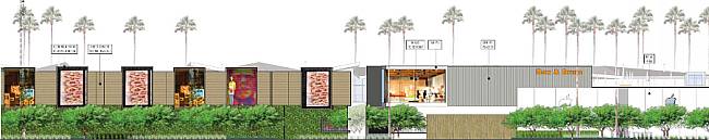 Image from Initial Study
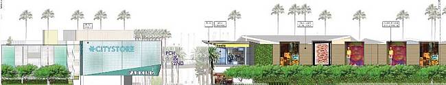
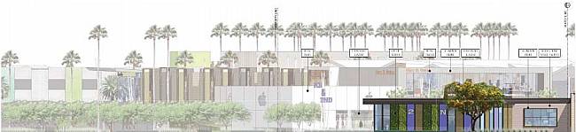
LBREPORT.com provides access below to the Initial Stufy in full, which indicates that the project applicant "proposes to replace the current Seaport Marina Hotel and associated amenities and surface parking with "a commercial development comprising approximately 245,000 square feet of floor area, including approximately 216,000 square feet of retail uses and approximately 29,000 square feet of restaurant uses." Initial Study, 2nd/PCH proposed development (Mar. 2014) The Initial Study acknowledges that the proposed project "could have potentially significant impacts under the CA Environmental Quality Act (CEQA) on the following environmental factors: "Aesthetics, Air Quality, Biological Resources, Cultural Resources, Geology and Soils, Greenhouse Gas Emissions, Hazards and Hazardous Materials, Hydrology and Water Quality, Land Use and Planning, Noise, Public Services, Transportation and Traffic, and Utilities and Service Systems." 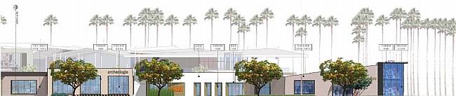 Image from Initial Study
Release of the document triggers a "public review period" (starting immediately) in which City Hall accepts public comments (in oral testimony and in writing) and ending on April 17, 2014. During this period, City Hall invites public comment and concerns regarding the proposed scope and content of the environmental information to be included in the project's EIR [Environmental Impact Report.] Additional public input will follow after a draft EIR is prepared and released. [Initial study text] ...The proposed uses would be provided within several one- and two-story buildings ranging in height from 20 feet to a maximum height of 35 feet. A total of 1,172 parking spaces would also be provided within a surface parking area and a three-level parking structure. Landscaped courtyards and open space areas would also be provided throughout the Project Site. The Project would have a total floor area ratio of approximately 0.5:1. In addition, setbacks of approximately 20 feet would be provided along all adjacent streets. Some of the conceptual site plans are below; there are additional illustrations in the document. The new proposed development has been downsized in height to meet the current coastal development limits of 35 feet. In December 2011, the City Council voted 3-5 to reject a zoning change/development entitlements for a proposed mixed use development with some midrise (some argued high rise) buildings that would have exceeded the coastal development height limits Voting "yes" in December 2011 to approve zoning changes to enable the previously proposed development were Councilmembers Garcia, DeLong and Gabelich; voting "no" were Councilmembers Lowenthal, O'Donnell, Schipske, Andrews, Neal; Johnson was absent.) The previous proposal was opposed by a number of coastal protection and environmental advocates, who voiced concerns about (among other things) impacts on the adjacent Los Cerritos wetlands (east of PCH adjoining The Marketplace commercial center.) Other residents voiced objectios based on traffic impacts at 2nd/PCH, which is already one of the most congested intersections in LB and regionally. Supporters of the previous proposal said the location, currently home to the aging Seaport Marina Hotel, is under-utilized, and said the location could be transformed into a lucrative and attractive gateway into Long Beach. The initial study text says in part: [Initial study description] [T]he retail and restaurant uses would be located within a series of one- and two-story st ructures situated primarily along 2nd Street and and Marina Drive with landscaped setbacks along the adjacent street frontages. Specifically, the 2nd Street frontage would be characterized by extensive landscaping and one-story structures ranging in height from 20 feet to 25 feet and featuring a variety of retail uses. Along Marina Drive, the Project would provide a landscaped setback and would include two-story structures ranging in height from 29 feet to 35 feet, which would include retail uses at the ground level and restaurant uses at the upper level. A large retailer located in a freestanding two-story, 35-foot-high building would be developed along the southern boundary of the Project Site, south of the retail and restaurant uses along Marina Drive. The Initial Study acknowledges a "Potentially Significant Impact" on Transportation/Traffic (that must be studied in a forthcoming Environmental Impact Report) 16. TRANSPORTATION/TRAFFIC. And regarding wildlife habitat and the nearby wetlands, the Initial Study states: [S]everal waterways and open space areas, which could provide habitat for sensitive species, are located in the general vicinity of the Project Site, including the Los Cerritos Channel, located north of the Project Site; the San Gabriel River, locate d south of the Project Site; the Los Cerritos Wetlands, located northeast of the Project Site; and the Alamitos Bay Marina, located west of the Project Site, across Marina Drive. While unlikely, the Project could result in an indirect impact to potentially sensitive species in these surrounding areas. Therefore, the EIR will provide further analysis of the Project's potential to indirectly impact off-site sensitive species. Developing...with further to follow on LBREPORT.com.
blog comments powered by Disqus
Contact us: mail@LBReport.com |
 Click for VIDEO and see how Diversified Threat Management private security can help protect your neighborhood and your business. Affordable group rates available.               Hardwood Floor Specialists Call (562) 422-2800 or (714) 836-7050  |
Contact us: mail@LBReport.com