City-Hired Consulting Firm Proposes New SE LB Zoning: Some Bldg Heights (Hotels/Residences w/ "Community Amenities") Along PCH Up To Seven Stories, Others Up To Five Stories...And For 2nd/PCH Traffic Offers Bike Lanes, Pedestrian Walkways
LBREPORT.com is reader and advertiser supported. Support independent news in LB similar to the way people support NPR and PBS stations. We're not non-profit so it's not tax deductible but $49.95 (less than an annual dollar a week) helps keep us online.
(Mar. 25, 2016, 12:25 p.m.) -- Some hotels and residential buildings up to seven stories high -- twice as high as currently allowed -- amid other commercial buildings up to five stories high instead of the current three stories -- would permanently intensify uses along parts of PCH in SE LB as part of proposed zoning changes advanced by a City Hall-hired consulting firm and released by the City's Development Services office.
Regarding LB's most congested intersection at 2nd/PCH, the 210 page document document proposes more bike and pedestrian paths, presumes shorter block lengths will promote walking and biking, urges a mix of uses to "capture more internal trips" and minimize vehicle use of streets...and suggests some people may not use their cars for short trips if offered a possible privately run shuttle circulator between areas like the VA Hospital, CSULB, Naples and Belmont Shore and perhaps the Convention Center.
The newly released "conceptual draft" for a "Southeast Area Specific Plan" is part of a City Hall move to replace SE LB's current (1977) master plan zoning (SEADIP) with "updated" allowable land uses.
LBREPORT.com hasn't had an opportunity to review the entire document in detail yet, but we note these salient items:
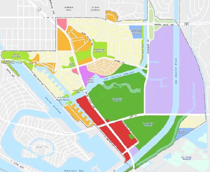
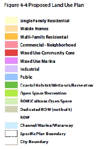
Regarding building heights within the Mixed Use Community Core area (red on the map below):
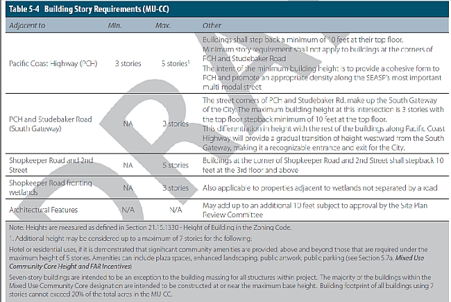
"Additional height may be considered up to a maximum of 7 stories for the following:
Hotel or residential uses, if it is demonstrated that significant community amenities are provided, above and beyond those that are required under the maximum height of 5 stories. Amenities can include plaza spaces, enhanced landscaping, public artwork, public parking [see text section 5.7a below]...
Seven story buildings are intended to be an exception to the building massing for all structures within project. The majority of buildings within the Mixed Use Community Core designation are intended to be constructed at or near the maximum base height. Building footprint of all buildings using 7 stories cannot exceed 20% of the total acres in the MU-CC...
...[5.7a "Mixed Use Community Core Height and FAR Incentives"] Projects in Mixed-Use Community Core areas [the red areas on the map below along PCH (west side) north of 2nd St., and both sides of PCH south of 2nd St] have the potential to exceed 5 stories in height (up to 7 stories) if additional amenities or improvements are provided. Following is a list of items that could be provided to be considered for additional height (up to 7 stories) in the "Mixed Use Community Core"
Addition of common open space (plaza or boardwalk area with public amenity / public art, water feature, etc.) above what is required for a project
Additional public parking (above what is required for project) for water or wetlands uses
Purchase of wetland mitigation bank credits above what is required for wetland mitigation
Purchase of acres of wetlands to be conveyed to the LCWA for long term operation, preservation, and maintenance above what is required for wetlands mitigation
Installation of enhanced landscaping in parkways or medians along primary corridors such as PCH, 2nd and Studebaker Road beyond what is required per the setback requirements above and Landscape requirements below (Section 5.5 d)
Installation of new renewable energy or solar facilities
Provision of moderate income housing units
Installation of public art
Hospitality and coastal recreation uses
Advertisement
Advertisement
The document discusses traffic in its section on "mobility"...and doesn't propose a connection or completion of Studebaker Rd. to PCH. "Since the wetlands were identified in the Vision as an asset to the community and a resource that should be retained and restored over time...this Specific Plan does not include a connection or completion of the Studebaker Road extension. However, this Plan proposes a few new opportunities for vehicular access as well as connections to proposed regional improvements. The recommendations provided are generally limited to refinements within the existing right of way to minimize affects on adjacent wetlands resources."
Advertisement
Advertisement
The document's mobility section proposes the following:
A mix of uses in the vicinity of 2nd and PCH to capture more internal trips to the area (minimize the number of vehicular trips that require use of dedicated roadways)
Shorter block lengths near the 2nd Street and Pacific Coast Highway intersection to promote walking and biking in the study area
Additional connectivity for bikes and pedestrians that connect people to their destinations, such as bike paths and better
pedestrian facilities between key destinations
Parallel pedestrian and bicycle linkages where they can be implemented without adversely impacting wetlands resources
Improved biking and walking environments such that people do not have to get into their cars to make short trips
Additional long-term mobility options such as the implementation of a privately financed shuttle circulator that could provide access to key destinations between the SEASP area, Cal State Long Beach, the Veteran's Hospital, Belmont Shore and Naples, and possibly the Convention Center.
...6.2.3 Vehicular Circulation and Access
Given the abundance of wetlands in the SEASP area, additional vehicular capacity and/or new roadway connections are limited.
For example, when PD-1 was approved in 1977, it included a provision to connect Studebaker Road north of 2nd Street to the existing segment that intersects with PCH near the entrance to the City.
Since the wetlands were identified in the Vision as an asset to the community and a resource that should be retained and restored over time. As a result, this Specific Plan does not include a connection or completion of the Studebaker Road extension.
However, this Plan proposes a few new opportunities for vehicular access as well as connections to proposed regional improvements. The recommendations provided are generally limited to refinements within the existing right of way to minimize affects on adjacent wetlands resources.
Local Vehicular Opportunities
This mobility plan proposes two new vehicular connections; the extension of Shopkeeper Road to tie into Studebaker, then south to PCH, as well as a Waterway Promenade connection to the property north of 2nd street and west of PCH.
Right-of-way has already been dedicated for the extension of Shopkeeper Road from its existing origin off of 2nd Street connecting to Studebaker. Constraints such as existing oil operations and proximity to the wetlands may preclude the roadway from being completed in the configuration in which it is currently proposed and will likely require a realignment at some point in the future.
A vehicular and/or pedestrian connection along the waterway adjacent to the existing Marina Pacifica development could create additional vehicular access as well as integrate a unique pedestrian boardwalk environment that supports the SEASP vision. A
roadway extension in this area could be a public or private roadway...
Additionally, the creation of smaller blocks and increased accessibility to mixed use areas are envisioned through connections such as the new roadway extensions as mentioned above and further discussed in Chapter 7, Design Standards and Guidelines. Access to future development should be created by use of a smaller block pattern with access to major roadways such as PCH and 2nd Street. Signalized entries would be included at many of the new access points spaced between 500' and 1000' apart as long as safe and efficient access can be
provided...
Advertisement
Advertisement
Whether these and other draft proposals are implemented, tweaked or modified -- or current low density protections are left in place as they are -- will be decided (after public hearings with public testimony) by votes of the LB City Council and the CA Coastal Commission. In December 2011, a now-former Council voted 3-5 against allowing a controversial mixed use development at 2nd/PCH (SeaPort Marina hotel site) for which city staff had recommended an "average" height of seven stories. The proposed development produced polarizing community responses over traffic and wetlands impacts versus economic development, with multiple residents arguing that the area's SEADIP zoning reflected a compromise that protects SE LB from increased density in exchange for accepting increased density downtown.
At the time, then-Councilman Robert Garcia was among the Council minority that voted to allow the controversial 2nd/PCH development, which was supported by Belmont Shore area business interests and opposed by the Los Cerritos Wetlands Land Trust and other environmental groups. A little over four years later, Garcia (now Mayor without a vote) and a new Council majority (with decisionmaking voting power) have frequently stressed what they call economic development in other contexts; how a Council majority will apply this in SE LB will be visible in the coming months.
Among the new Council majority is Councilman Roberto Uranga, who was among the slim majority of Coastal Commissioners who voted in Feb. 2016 to remove the agency's Executive Director, spurring charges -- that Uranga calls false -- that the action reflects a new Coastal Commission majority tilt toward approving increased development in CA's coastal areas.
The bottom line: Southeast Long Beach will now become ground zero for these issues, since whatever a City Council majority votes to approve and a Coastal Commission majority votes to accept will effectively determine the future of SE LB and what is acceptable in the area's coastal zone.
Some of the public meetings on SEADIP (now SEASP) have used a technique that effectively prevents the public exchange of viewpoints, a format fundamentally different than the traditional American "Town Hall" where residents can speak and be heard in discussing community issues. In contrast, at the LB meetings, the City Hall hired consultant presents its contentions at length (usually accompanied by Power Point sldies) and the public doesn't get an opportunity to respond to speak where they can be heard by others at the meeting. Instead, attendees are directed to state their views/ask questions individually (verbally or in writing on cards) with answers later.
A meeting that may follow such a format -- this time on the newly released "conceptual draft" of the "Southeast Area Specific Plan" -- is scheduled for March 26, 2016, 11 a.m. to 3 p.m., at the Best Western Golden Sails Hotel, Seafarer Room, 6285 E. Pacific Coast Highway. LB's Development Services bureau website describes it as an "Open House" with an opportunity to [City Development Services webpage text] "[m]eet one-on-one with the project team to learn about the components of the Draft Specific Plan (Plan); how the Plan will implement the community's SEASP Vision, and ways to stay involved with the project."