6th Dist. Council Incumbent (Since 2007) Dee Andrews Says He'll Wage Write-In For Another Term
LBREPORT.com is reader and advertiser supported. Support independent news in LB similar to the way people support NPR and PBS stations. We're not non-profit so it's not tax deductible but $49.95 (less than an annual dollar a week) helps keep us online.
(May 22, 2015) -- Sixth district (Central LB) Councilman Dee Andrews has announced he will wage a write-in campaign to seek another term on the City Council. First elected to the Council in a winner-take-all special election in 2007 (after then-Councilwoman Laura Richardson sought and won Assembly seat in fall 2006), Andrews was reelected in 2008 and (with no opponent) in 2012.
If candidates do announce in the 2016 Central LB Council district race, Andrews would have to defeat them outright (50%+1) as a write-in, or finish first and or second as a write-in to qualify for a June 2016 runoff in which his name would appear on the ballot.
A release issued by an experienced campaign consultant, Derek Humphrey, quotes Councilman Andrews as saying:
I'm proud of my record, working to improve and protect Sixth District neighborhoods but there is much work that still needs to be done and there are projects I want to see through to completion," said Andrews. "After a lifetime in central Long Beach, I think voters have a pretty good idea of who I am, what I stand for, and what they can count on me to fight for.Today, I will begin what is likely to be my final political campaign, by asking voters to write my name in to allow me the honor of continuing to represent them at City Hall."
Developing. Further to follow.
[Scroll down for further.]
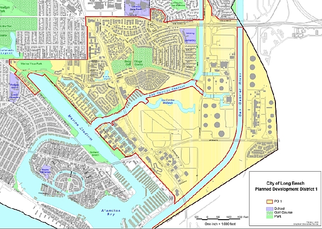
Current SEADIP zoning map
Prior to discussing SEADIP,the Planning Commission meeting (start time: 5:00 p.m.) first took up entitlements for three downtown projects (approved without dissent despite testimony by Ann Cantrell, and concern from some Commissioners, about removing currently-available parking locations and the loss of view corridors.) The Commission then held a study session on proposed development of the former Will J. Reid scout camp. Shortly before 9:00 p.m., the Planning Commission began up the SEADIP study session item, on which public comment was invited at about 9:45 p.m...by which time a number of people who attended the meeting had left.
Those who remained reiterated concerns voiced throughout process: that increased SE LB density would worsen the area's existing traffic problems (which they said couldn't be remedied by simply extending Shopkeeper Rd.) and could increase pressure to "solve" the problems at the expense of currently protected areas.
[Scroll down for further.]
Advertisement
Advertisement
The consultant firm said its approach was first to look at what it said the market wanted, citing an economic analysis, and then incorporate this into what it said public wanted, based on input at public meetings, questionnaires and the like. In mentioning a possible extension of Shopkeeper Rd. to PCH, the consultant rep (as in previous presentation) left vague possible proposed routes.
The Los Cerritos Wetlands Land Trust (LCWLT) questioned the consultants' foundational economic analysis, said the Planning Commission [and the public] needs to see economic figures underlying the consultants' density recommendations...and said that extending Shopkeeper Rd. wouldn't remedy traffic issues, especially if increased density worsens traffic to 2nd/PCH (already the city's most congested intersection.)
Attorney Mel Nutter [representing LCWLT, former chair of CA Coastal Commission] noted that although he'd just sworn an oath to tell the whole truth and nothing but the truth, he wasn't sure that was possible within the three minutes allotted to individual speakers. Mr. Nutter said that in 2010, the City (in dealing with the Golden Shore Local Coastal Permit amendment process) made a point in a document it submitted to the Coastal Commission that the original planning documents prepared and submitted by the City and approved by the Coastal Commission were designed to focus most of the density and most of the high rise in the downtown area in part to protect and relieve some of development pressure down-coast or in eastern portions of the city [now part of the SEADIP area.] Mr. Nutter testified to the Planning Commission: "So as you consider any kind of a plan, I trust you will consider the City's long time position that lower density and far more sensitive set of planning principles ought to be applied when dealing with this particular area."
Mr. Nutter also said that LCWLT had concerns about some of the economic analyses used to justify the consultants' planning judgments (saying they didn't appear to be feasibility studies but rather a series of conclusions that may or may not be bolstered by a traditional feasibility study.) Mr. Nutter said that if, as he heard earlier in the consultants presentation, some type of economic organization did some kind of additional feasibility analysis or study, the Planning Commission [and thus the public] needs to be able to see it.
[Scroll down for further.]
Advertisement
Advertisement
LCWLT Exec. Director Elizabeth Lambe noted that her organization had supported the SEADIP updating process because zoning for the area had become old and out of date, with inappropriate developments continually proposed, "but we are concerned about heights that can continue to be up to seven stories based on what at this point is unclear exceptional community benefits that's more than double the current zoning...I myself haven't sen sufficient economic data for me to understand the mandate for more than double the existing heights for the zoning of the area, even bumping it up to five stories...[That concerns me because] if you're going to bring in more housing and more developments and more density, you're going to increase the traffic [cites 2nd/PCH]...With all this more development how much more difficult the traffic will be.
And I hear this discussion about extending Shopkeeper Road, and perhaps there's a role for something like that, but how does that help with the traffic that goes from Westminster to 2nd St. That's important data that I think everybody needs to look at before the conversation about this density continues. I've been in conservation for a long time, and I'm here to tell you, that when traffic gets that bad, people start to eye nearby open spaces and so intense traffic makes me concerned about the fate of Los Cerritos wetlands despite the fact that it has the protections of the Coastal Act."
Ms. Lambe said that from the point of view of the Land Trust, we think there needs to be robust and detailed analysis of the potential environmental impacts including light, pollution impacts, noise, runoff, wildlife corridor analysis, bird trajectory and mammal tracking. She added, "Sometimes people think of environmentalists as being unyielding, but you need to remember that the vast majority of southern California wetlands are gone forever. The few scraps that remain are more than important and need to be preserved."
[Scroll down for further.]
Advertisement
Advertisement
Belmont Shore resident Dina Deck, said that if allowable heights were raised to 5-7 stories "you are taking a piece of property [from] which you can now see the San Gabriel Mountains and taking that away from much of the public [and the view in the other direction]..."
Melinda Cotton [30+ year Belmont Shore area resident, former Belmont Shore Residents Ass'n president] said traffic impacts would affect 2nd St. all the way to downtown...and said there are times when traffic is already backed up on 2nd St. to the library at Bay Shore Ave. She said adding Shopkeeper Rd. to PCH wouldn't help in cases when people come from downtown or exit the 405 freeway and use Westminster to downtown. Ms. Cotton added that increased building heights would end views of the San Gabriel Mountains from 2nd St. crossing the bridge and that "people from Naples had spoken about how their views to the east would be sabotaged by high rises." She said, "It's going to change the whole tenor of that area if there's too much density, too much height."
A representative of 2H construction -- which owns the triangular 6400 Loynes Drive vacant parcel [in March 2009, property owner stripped vegetation after Fire Dept. weed abatement directive but without Coastal permit; Coastal Comm'n enforcement action resulted in restoration of the land] -- said the property was historically "a closed dump" and it is "absolutely irresponsible that this property could be converted to a wetland" [offered citations, correspondence.] He indicated that 2H is now proposing to use the land for "a dry marina with a boat launch, essentially boat storage with a boat launch." [Editor's note: Some years ago, the land owner indicated he was considering building a soccer field on the site.] 2H's representative said a dry boat launch would be permissible under the now-proposed designation but added, "It is inappropriate and somewhat misleading to community to put a designation of wetland on a property that so many other responsible ;resource agencies have provided documentation cannot be a wetland."
SEADIP's current height limit is 35 feet (roughly three stories), a limit that contributed to opposition and ultimately to Council majority rejection of a mixed-use development exceeding current height levels at 2nd St./PCH (Seaport Marina hotel site.) [The Dec. 2011 Council vote was 3-5 (Yes: Garcia, DeLong, Gabelich; No: Lowenthal, O'Donnell, Schipske, Andrews, Neal; Johnson absent.] That project's failure to gain majority approval led to an immediate motion to pursue what is the now-ongoing SEADIP re-write.
At the conclusion of its presentation, the consultant firm's rep indicated it's moving forward to prepare a project description, a CEQA initial study for a public meeting on the scope of the draft EIR, coordinating with the Coastal Commission and community groups...and taking its land plan forward. That includes creating multiple technical studies on topics including traffic, biological, air and noise and preparing the specific plan in the draft EIR for Planning Commission and City Council review. The consultant indicated that at some point in 2016, the proposed project will be brought to the Planning Commission and the Council for review, more public comment, and action.
A City Council majority will ultimately vote on SEADIP zoning revisions, that can be enacted subject to subsequent Coastal Commission approval and court challenges, if any.
Further to follow.
Disclosure: The Los Cerritos Wetlands Land Trust has an informational ad spotlighting its monthly walks through the wetlands area running on LBREPORT.com.