Supporters say the prospect of restoring 150+ acres of wetlands is a game changer, an offer not made by the prior oil field's owner/operators, an opportunity that may not come again. If the City doesn't approve the plan, Synergy Oil could presumably continue its present surface oil drilling operations leaving the degraded wetlands as they are. They note that this is the first and only offer by an operator of the oil field to do anything of this magnitude...and it proposes the wetlands restoration without consuming taxpayer dollars.
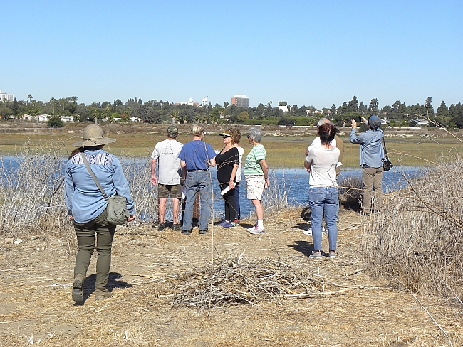
In October, the operator offered the public an opportunity to take a walking tour of the area. LBREPORT.com shot video of what we saw and heard and reported it with VIDEO below and accompanying text with VIDEO at this link.
The tour included a view of "Steamshovel Slough," not easily seen from offsite, that wetlands supporters call one of the most pristine salt marshes in all of Southern California.
Tour reaches
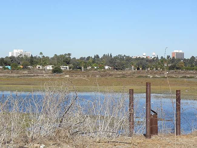
The company says if surface oil drilling is removed under proposed wetlands restoration, a berm at the southern end of "Steamshovel Slough" (currently used to prevent water from reaching the current surface wells) would be opened to allow natural wetlands to expand, that could presumably look something like the photo below.
Sponsor | Sponsor |
Opponents say the company's proposal is basically an oil drilling plan, not a wetlands restoration plan and have raised a number of issues. The include a risk of pipeline breakage and oil spills; continued reliance on fossil fuels that contribute to global warming; skepticism over company assurances that it doesn't plan to use fracking (hydraulic fracturing of rocks) as some opponents say oil drilling routinely uses somewhat similar procedures; use of a "mitigation bank" to pay for the wetlands restoration (using payments made by polluters at other locations); and the continued for-profit use of a site historically used by LB's former Native American Tongva tribe for sacred and burial purposes.
On Oct. 21, project opponents demonstrated outside the site. On November 2, 2017, a number of opponents testified at a meeting of the Los Cerritos Wetlands Authority (a four member government body comprised of LB Councilmembers Suzie Price and Roberto Uranga, a Seal Beach Councilmember and an appointee of the State Coastal Conservancy) when it received an update on BOMP's proposal. A press release indicates the opponents plan to testify at today's Planning Commission meeting.
The elephant in the room is the Los Cerritos Wetlands Land Trust (LCWLT), a private non-profit group that has devoted decades of work to preserving and trying to restore the wetlands. LCWLT hasn't taken a formal position pro or con on the restoration project at this point. In relatively short written comments to the draft EIR submitted by a retained law firm, the Los Cerritos Wetlands Land Trust generally expressed concerns (summary paraphrase) that included the lengthy timeline proposed for removing the surface oil drilling, currently proposed to span several decades.
Sponsor |  |
In written responses to these and other previous written comments received, the City's EIR responses say the risk of oil spills currently exists and would continue to exist without the proposed project...and suggested that the risk may be reduced in some respects by using new equipment...and repeatedly says the operator doesn't plan to use fracking to free up oil. The EIR does acknowledged that operator plans to separate water extracted as part of the oil drilling process, treat it and re-inject it back into the ground to prevent ground subsidence...but the City's EIR and its responses to public comments say the process isn't anticipated to create a significant risk of inducing seismic activity on the Newport-Inglewood fault. (The fault, which is still considered active, caused the 1933 earthquake epicentered near Huntington Beach that destroyed/damaged multiple buildings in Long Beach.)
In written comments to the EIR, Coastal Commission staff noted that the proposal would allow 160 foot drilling rigs for up to 11-14 years at both the Pumpkin Patch and 2nd St./Studebaker NE coner, which the EIR avoided analyzing by labeling this a "temporary" use (and the Coastal Commission staffer recommends be considered a permanent imapct.) [Veteran Shore-area advocate Melinda Cotton says it appears at least one of the 160 foot drilling rigs will be in place on each site for the duration of drilling new wells, and a 120 foot collapsable "workover" rigs will also be in use at the site.] p>Councilwoman Suzie Price, in whose district the site is located and who also sits on the governing board of the Los Cerritos Wetlands Authority (a governmental body) has indicated she plans to listen closely to today's Planning Commission proceedings...as the matter will eventually reach her as a decisionmaking City Councilmember.
LBREPORT.com plans to live stream today's Planning Commission hearing on our front page starting at 5:00 p.m.
Sponsor | Sponsor |
blog comments powered by Disqus
Recommend LBREPORT.com to your Facebook friends:
Follow LBReport.com with:
RSS |
Contact us: mail@LBReport.com


Hardwood Floor Specialists
Call (562) 422-2800 or (714) 836-7050
