


3853 Atlantic Ave.

|
Click here |
CA Air Resources Bd. 2000 Map Indicates LB Airport Vicinity Has Highest Inhalation Cancer Risk in LB
(October 20, 2003) -- The CA Air Resources Board (ARB) has posted a map (below) on its web site reflecting the agency's assessment of inhalation cancer risk for the 2000 calendar year, indicating the LB Airport vicinity has an elevated inhalation cancer risk...exceeding the rest of LB (including the Port) which is already at higher inhalation cancer risk than many L.A. & OC areas.
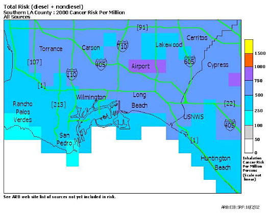 The finding is particularly significant since CA ARB's web site says aircraft emissions were not included in the agency's analysis. "Aircraft emissions (commercial/military/civil) currently need work related to geographical distribution." CA ARB says. The map is (obviously) not detailed, and CA ARB notes that the "finest visual resolution available in the maps on this web site is 2 kilometers by 2 kilometers. Therefore, individual neighborhoods, or single facilities do not show up on these maps." As separately reported by LBReport.com, a study of the effects of LB airport on LB residents was requested by Vice Mayor Frank Colonna and Councilmembers Dennis Carroll, Jackie Kell and Rob Webb in May 2002...but to date has not been delivered. On October 14, 2003, Councilmembers revisited the issue and directed the City Manager to present options in early December 2003 for providing such a report [obviously now delayed into 2004] either separately or as part of an upcoming EIR to expand the Airport's permanent terminal facilities. CA ARB's web site allows one to view separate maps showing cancer risks attributable to diesel vs. After clicking on CA ARB
Cancer Inhalation Risk: Local Maps by Category, click drop down window at left, then select "L.A.-South." Boxes on the left let one select between diesel and CA ARB's maps indicate somewhat lower cancer risks for LB and LA port adjacent areas than the AQMD's MATES-2 (multiple air toxics exposure study) study. Asked by LBReport.com to comment on the differences, AQMD Health Effects Officer Jean Ospital, DRPH, noted the data were obtained in different time periods (MATES-II in 1998, CA ARB later) and some modeling is probably different. "Perhaps the message is, rather than trying to figure out the differences, figure out how they're similar may be more important," Dr. Ospital said...noting that both agencies found diesel emissions were the significant risk contributor. "In that sense, the AQMD MATES-II and CA ARB are in agreement: the bulk of the cancer risk is from diesel sources, especially mobile diesel," he noted. Dr. Ospital added that AQMD is scheduled to begin its MATES-3 study next year with a new round of monitoring. CA ARB's web site notes that its 2000 maps reflect "a significant decrease in the risk estimate for marine shipping diesel particulate matter in the Los Angeles-Long Beach Harbor area" based on the following: Treating the marine shipping emissions in the LA/LB Harbor region as moving point sources has dramatically reduced the modeled risk in this area. The old method treated the ships as ground level stationary sources, while for these latest risk maps we used a new emissions data set for marine shipping. This data set contains estimates of ship emissions, locations for specific time periods, ship stack heights, and other stack parameters which allow a more realistic modeling of the ambient concentrations of diesel emissions to be undertaken. Based upon monitors in the region, it has been determined that this new method probably reflects a more realistic picture of the risk due to marine diesel emissions. LBReport.com reminds readers that these maps only indicate inhalation cancer risk. They do not include risks of other life eroding and fatal diseases such as emphysema, chronic obstructive pulmonary disease (COPD) and other lung and heart illnesses. As is conventional in cancer risk assessments, both the CA ARB and AQMD's maps reflect the estimated lifetime cancer risk (i.e. the risk of cancer from such exposure over 70 years). CA ARB's web site indicates the following categories were not included in its analysis: Regarding risk, CA ARB's web site states in part: There are risks evident in all aspects of our lives. The level of risk varies with the activity and the environment that the activity takes place in. The objectives of the ARB's Toxic Air Contaminant Identification Program and Toxic Air Contaminant Control Program are to identify sources of toxic air contaminant health risk, prioritize them, and try to find feasible ways to reduce the risk, while maintaining a healthy, vibrant economy.Toxic compounds have different effects on different individuals. The toxicity of certain compounds may also vary in complex ways based upon the level and duration of exposure. Other environmental factors, such as climate, can influence both the level and impact of exposure. In addition, other compounds that are present at the same time, or that the individual has been previously exposed to or could later be exposed to, may change the toxic impact on the individual. For a more extensive discussion of compound toxicity and the assignment of risk, visit the Toxic Air Contaminant Identification Program web site. These maps were produced by applying cancer inhalation risk factors determined by peer review to modeled toxic air contaminant concentrations. The cancer inhalation risks are in units of cancer risk per million people, which represents the lifetime risk that one person in a million may contract cancer from inhalation of the toxic compound at the modeled ambient concentration. The values shown on these risk maps should be viewed as a gauge of relative risk, rather than as an absolute risk determination. These maps are very useful for determining the geographic locations where current science indicates that the greatest amount of risk from toxic air contaminants exists. However, the absolute risk numbers shown on the maps should NOT be used as the basis for determining personal risk. CA ARB notes that the "finest visual resolution available in the maps on this web site is 2 kilometers by 2 kilometers. Therefore, individual neighborhoods, or single facilities do not show up on these maps." And CA ARB's web site adds that its "maps are a working draft...ARB staff is working to improve [its] knowledge base." |