See SEADIP (SE LB Zoning) Consultant-Prepared Four Development Scenarios; Conceptual Options Presented To Advisory Committee For Discussion Include Potential Height And Density Increases
by Joe Mello
LBREPORT.com Community Correspondent
Includes additional reporting by Bill Pearl
(Oct. 31, 2014) -- The South East Area Development Improvement Plan (SEADIP) Advisory Committee held its fifth community workshop on Wednesday October 29, 2014, giving the public its first look at four conceptual option scenarios prepared by a city staff-hired consultant firm that could serve as the basis for changing zoning and land uses in SE LB.
An LB city staff hired consulting firm ("PlaceWorks," headquartered in OC) collected public input at prior SEADIP Advisory Committee meetings and at the Oct. 29 meeting gave a Power Point presentation proffering four scenarios, half of which included height and density increases. Consultant reps said the scenarios aren't "all or nothing" plans but scenarios that could be incorporated in various developments throughout the SEADIP area.
[Scroll down for further]
Photo by Joe Mello
The consultant presentation began with an overview of "market feasibility basics" as part of the economic component of sustainability that included a discussion of market assessments, land value and planning constraints.
The presentation said "existing land use regulations create uncertainty and risk for developers and land owners" and stated the constraint of land regulation could be "mitigated" as part of the planning process. Developers' "point of views" were also briefly addressed with promises of a future pro forma analysis at a future community meeting on the four presented scenarios.
Below are the four consultant presented scenarios, offered as scenarios for use in various developments throughout the SEADIP area, not "all or nothing" plans:
Scenario One: "Shop" included single story retail buildings with a "street orientation" This concept had buildings located adjacent to the streets with parking in the back of the buildings. Parking configuration was a repeatedly stated concern among the 22 member SEADIP Community Advisory Committee.
Scenario Two: "Shop/Live" included mixed-use residential and retail within the current SEADIP 35 foot maximum height restrictions. The scenario's "Live" addition prompted discussion among the Advisory Committee about Coastal Commission considerations. The posted SEADIP planning timeline indicates discussions/coordination with the Coastal Commission [staff] beginning after the next SEADIP advisory panel workshop (December 8, 2014.)
Scenarios Three and Four: "Shop/Live/Stay" included residential, retail and hotel uses.
Scenario Three would include buildings up to five stories approximately 60 feet.
Scenario Four would have 5-7 story buildings. At roughly 10 feet per story [precise height may be different], a seven story building would be roughly 70 feet high -- double the current 35 foot restriction.
To view the Power Point presentation slides, click here.
Scenarios Three and Four prompted concerns and discussion about density from Community Advisory Community members. Elizabeth Lambe, the Los Cerritos Wetlands Land Trust representative, first addressed the density issue and said the original SEADIP when adopted was intended to prevent tall structures in SE LB, reserving those for the downtown urban area. (Later during public comments, audience members stated that this was their SEADIP understanding as well.)
Traffic Engineer Jason Pack [project team member from Fehr & Peers] presented data on the impact on traffic for the four scenarios...and said there was "no silver bullet" for the SEADIP area traffic. Mr. Pack said the SEADIP area currently produces 119,394 daily driving trips into and out of the area, a number that doesn't include trips that pass through the SEADIP area or currently proposed projects in the area.
Mr. Pack's study showed that each Scenario One development in the area would add 2% more daily trips. Each Scenario Two mixed-use development in the area would add 1% more total trips. Every Scenario Three project built would add 3% more daily trips and every Scenario Four project built would add 5% to the daily trip amounts.
The main focus of improving traffic in the area in Pack's presentation was "improving mobility" to the area's major surface streets: PCH; Studebaker; Loynes; Marina; Shopkeeper and 2nd St.. Pack stated that extensions of streets like Shopkeeper would help improve the area's mobility. Studebaker's extension is controversial because it would be through the wetlands and wasn't explicitly mentioned in the presentation.
PCH was a central part of most of the evening's presentations -- including describing it as having the potential of a "grand boulevard." Mr. Pack noted that PCH is maintained as a state highway under CALTRANS jurisdiction and any SEADIP "streetscape plans" for PCH would require state approval to turn the SEADIP portion of the highway over to the City of Long Beach.
At the end of the over two hour presentation, community members in the audience were given the chance to comment. A number of speakers supported Ms. Lambe's point that SEADIP's intent was to restrict density in South East Long Beach in favor of density in LB's urban downtown.
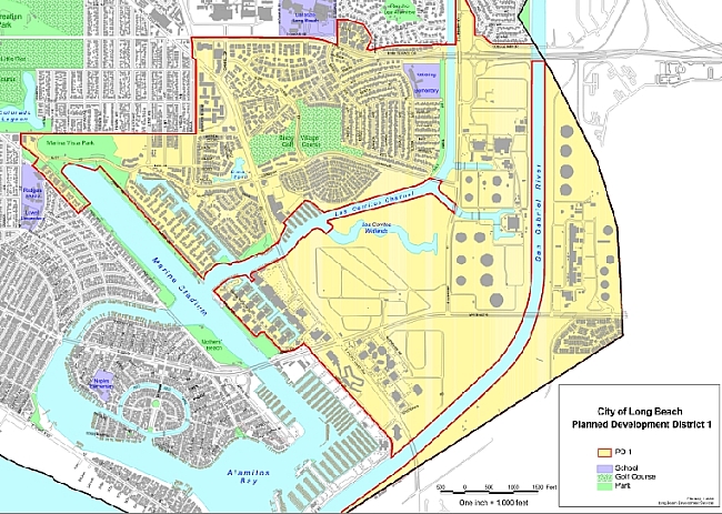
Current SEADIP zoning. Map source: City of Long Beach
Long time Long Beach environmentalist Ann Cantrell spoke against any development next to the wetlands along the east side of PCH, bluntly calling it "a bad idea". Commenting on the presented scenarios, Cantell told LBREPORT.com: "I'm really concerned about the plans show tonight that showed 5-7 story buildings along the east side of PCH next to the wetlands. This would cut off views of the public, access to the public and in addition it would endanger the wildlife and the birds at the wetlands. So I am hoping this will be written out of the plan."
Ms. Cantrell also had concerns about the presentation's statements on mitigating the land restrictions through the SEADIP process:
[Ms. Cantrell] My first thoughts is they should of gone to the Costal Commission long before this. Before they even started the planning process because their are constraints the Coastal Commission will be putting on them. They seem to be clueless -- the design team seems to be clueless about what those constraints might be.
I believe what the Costal Commission is charged with allowing the public access to the coast and to the coastal waters is their number one priority.
Yes, they have allowed other uses, but they frown on residential uses and I just can't believe they would allow a coastal plan to a allow a lot of residences. Now I could be wrong, but I think they say they are going to talk to the Coastal Commission and at some point, but I think it should of been done before this.
Ms. Cantrell added her thoughts about the Community Advisory Committee telling LBREPORT.com: "I think there are a lot of thoughtful people on this committee that are steering the consultants in the right direction."
The city staff-selected SEADIP Advisory Committee (for member list, click here) says it aims to envision the area 50 years from now in 2060. The current SEADIP zoning document (which development interests have criticized as outdated) was adopted less than forty years ago in 1977.
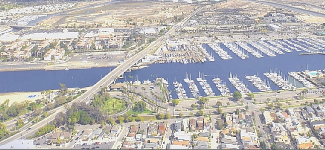
Image source: City of Long Beach
The SEADIP Advisory Committee's recommendations (plus any additional city staff recommendations) will eventually reach the City Council, triggering a lengthy public hearing/planning process (including approval of an accompanying EIR for proposed changes.) The issues will percolate through LB's non-elected (Mayor selected/Council approved) Planning Commission, then reach LB's elected City Council where a majority will make voted choices, with review (for voted approval/rejection) sent to Sac'to's chosen CA Coastal Commission. The end result could change zoning and land uses across a large portion of SE LB.
For years, developers have had to live with SEADIP's current restrictions [some community members would say protections] or seek City Council (and Coastal Commission) ad hoc approval for specific developments. Former 3rd dist. Councilman Gary DeLong made an effort to advance an overall update to SEADIP but it foundered after some criticized DeLong's-chosen advisory panel as less than transparent.
In December 2011, a developer-propelled proposal to put a partial high rise/mixed use development at the 2nd/PCH Seaport Marina hotel site failed to gain Council majority approval. (The vote was 3-5, Yes: Garcia, DeLong, Gabelich; No: Lowenthal, O'Donnell, Schipske, Andrews, Neal; Johnson absent). Public issues included traffic, height, Coastal zone standards and wetlands impacts.
Following the 2nd/PCH vote, the Council unanimously approved launching a new SEADIP update that it said would be transparent and faithful to community input.