Man Is Shot/Wounded Sitting In Parked Car, Area 56th St./Linden Ave. (8th Dist.)
If LBREPORT.com didn't tell you, who would?
No one in LBREPORT.com's ownership, reporting or editorial decision-making has ties to development interests, advocacy groups or other special interests; or is seeking or receiving benefits of City development-related decisions; or holds a City Hall appointive position; or has contributed sums to political campaigns for Long Beach incumbents or challengers. LBREPORT.com isn't part of an out of town corporate cluster and no one its ownership, editorial or publishing decisionmaking has been part of the governing board of any City government body or other entity on whose policies we report.
LBREPORT.com is reader and advertiser supported. Support independent news in LB similar to the way people support NPR and PBS stations. We're not non-profit so it's not tax deductible but $49.95 (less than an annual dollar a week) helps keep us online.
(December 18, 2019) -- A man (adult) was shot/wounded and his vehicle was damaged in a shooting in the area of 56th St./Linden Ave. (one block west of Atlantic Ave., just south of South St., 8th Council district.)
LBPD Public Information Officer Shaunna Dandoy tells LBREPORT.com that at about 11:10 p.m. on Dec. 17, officers responded to a hospital where a man (adult) was being treated for a gunshot wound.
LBPD says preliminary information indicates the victim was seated in his vehicle when an unknown suspect(s) fired at him, striking him and his vehicle. Assisting officers responeed to the crime scene and locating casings.
There's no immediate suspect information or motive...and LBPD's investigation is ongoing.
[Scroll down for further.]
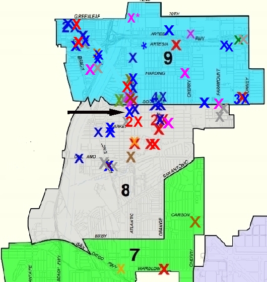
The first map below shows shootings cumulated from Jan. 1, 2018 to Dec. 17, 2019
Jan 1, 2018 to date: Red Xs=homicides; Blue Xs= shootings, person wounded; Brown Xs=shots fired at victim(s), not hit; Purple Xs=shots at occupied residence/vehicle; Green Xs= shots at unoccupied vehicle/residence; Grey Xs=shots fired (no hit, no target identified); Orange X's=non-fatal stabbings; Blue * asterisk=victim hit, police unable to locate crime scene. Map is unofficial. NLB.shootings are on separate map.
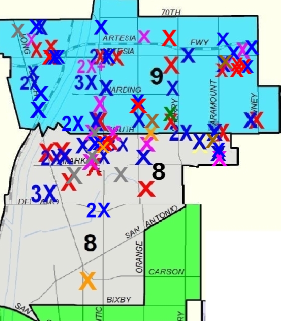
For context, the second map shows shootings cumulated from Jan. 1, 2014 through Dec. 31, 2017.
Sponsor
Sponsor
Sponsor
Sponsor
Sponsor
Sponsor
Sponsor
Support really independent news in Long Beach. No one in LBREPORT.com's ownership, reporting or editorial decision-making has ties to development interests, advocacy groups or other special interests; or is seeking or receiving benefits of City development-related decisions; or holds a City Hall appointive position; or has contributed sums to political campaigns for Long Beach incumbents or challengers. LBREPORT.com isn't part of an out of town corporate cluster and no one its ownership, editorial or publishing decisionmaking has been part of the governing board of any City government body or other entity on whose policies we report. LBREPORT.com is reader and advertiser supported. You can help keep really independent news in LB similar to the way people support NPR and PBS stations. We're not non-profit so it's not tax deductible but $49.95 (less than an annual dollar a week) helps keep us online.