LBReport.com

News / In Depth

L.A. River @ Wardlow Rd. Rose Sharply But Remained Well Below Flood Stage During Relatively Quick Storm...But In Longer Storm, How Might Retaining Current Shoemaker Bridge As Park Alongside New 710-Downtown Bridge Affect River's Capacity And Flood Risk?


If LBREPORT.com didn't tell you,
who would?
No one in LBREPORT.com's ownership, reporting or editorial decision-making has ties to development interests, advocacy groups or other special interests; or is seeking or receiving benefits of City development-related decisions; or holds a City Hall appointive position; or has contributed sums to political campaigns for Long Beach incumbents or challengers. LBREPORT.com isn't part of an out of town corporate cluster and no one its ownership, editorial or publishing decisionmaking has been part of the governing board of any City government body or other entity on whose policies we report.

LBREPORT.com is reader and advertiser supported. Support independent news in LB similar to the way people support NPR and PBS stations. We're not non-profit so it's not tax deductible but $49.95 (less than an annual dollar a week) helps keep us online.
(December 23, 2019, 1:30 p.m.) -- Within a one hour period, the L.A. River just south of Wardlow Road rose nearly five feet...from 1.45 feet at 1:15 a.m. PT to 6.41 feet at 2:15 a.m. And it stayed at about the level and hit 6.61 feet at 4:45 a.m., its high mark before subsiding after the intense but relatively short downpour.

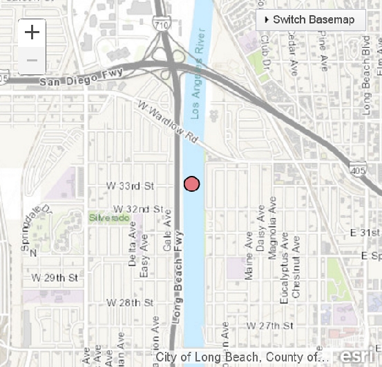
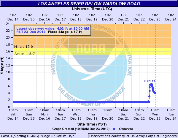
This level was well below the L.A. river's "flood stage" just south of Wardlow Rd., the maximum drainage point for the entire 815 sq. mile L.A. County drainage area.


NOAA website
NOAA website

However this was a relatively brief event. Rain began hitting the west L.A./PV/LB area in earnest shortly before the 9 p.m. hour (Dec. 22) and peaked around 2 a.m.-3 a.m. (Dec. 23) at LGB before rainfall rates began dropping in roughly the 4 a.m. hour.

But that doesn't always happen. Some storms stretch much further into the Pacific and last for days (including the "Pineapple Express" and "atmospheric rivers.") In addition, by January and February, the ground is often saturated from previous rainfall, sending more runoff into the L.A. river and ultimately into LB.

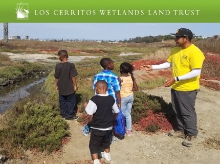
Yet to date Long Beach's policy-setting City Council hasn't publicly date discussed the impacts on the L.A. River's carrying capacity that would result from a project proposed by Mayor Robert Garcia.

[Scroll down for further.]:


As part of plans to widen the I-710 freeway and build a new bridge connecting the freeway with downtown LB, Garcia has proposed a concept similar to New York City's "High Line" park (which reused a former elevated RR bridge as a park). Mayor Garcia has proposed to retain the existing Shoemaker Bridge and turn it into a pedestrian park like trail. LBREPORT.com has called the idea intriguing and worthy of exploration, but has also raised cautions about its impacts on the L.A. River's capacity to handle major storms and increased runoff (the latter expected to increase as future development locally and upriver paves over previously permeable surfaces.)

Sponsor

Sponsor

Putting a new bridge in the L.A. River while retaining the current bridge would increase the number of obstructive pilings/piers in the river channel and reduce the river channel's carrying capacity. (NYC's High Line RR bridge is in Manhattan, not across a river.) The I-710 bridge's EIR acknowledges these impacts but downplays them, calling them not significant and minimizing any increased flood risk, but the impacts are visible on a close reading of the text and data (described in LBREPORT.com's coverage at this link.,

Sponsor

Sponsor

In addition, the new bridge's proposed design has morphed from the iconic gateway project described by LB's now former Public Works Director (who exited LB for Pasadena) into what now arguably appears to be basically a conventional freeway connector. (The design also proposes "traffic calming" [slowing] elements that haven't been seriously discussed publicly at this point. LBREPORT.com wonders how many taxpayers favor installing a "roundabout" or a "Y" intersction" at the downtown/eastern end of the I-710 connecting bridge.)

To view LBREPORT.com previous report New Shoemaker Bridge -- Proposed As Iconic New Entrance To Downtown LB -- Might End Up Considerably Less; City Council (Including Its "I-710 Oversight Committee") Hasn't Paid Attention And Some LB Media Outlets Haven't Told You These Details. click here.

Sponsor


Sponsor

Sponsor


Support really independent news in Long Beach. No one in LBREPORT.com's ownership, reporting or editorial decision-making has ties to development interests, advocacy groups or other special interests; or is seeking or receiving benefits of City development-related decisions; or holds a City Hall appointive position; or has contributed sums to political campaigns for Long Beach incumbents or challengers. LBREPORT.com isn't part of an out of town corporate cluster and no one its ownership, editorial or publishing decisionmaking has been part of the governing board of any City government body or other entity on whose policies we report. LBREPORT.com is reader and advertiser supported. You can help keep really independent news in LB similar to the way people support NPR and PBS stations. We're not non-profit so it's not tax deductible but $49.95 (less than an annual dollar a week) helps keep us online.


blog comments powered by Disqus

Recommend LBREPORT.com to your Facebook friends:


Follow LBReport.com with:

Twitter

Facebook

RSS

Return To Front Page

Contact us: mail@LBReport.com


,/a>


Copyright © 2019 LBReport.com, LLC. All rights reserved. Terms of Use/Legal policy, click here. Privacy Policy, click here