Corps Of Engrs Nixes Breakwater Changes, Cites Objections to Increased Wave Activity By Maritime, Naval, THUMS, Port Interests
If LBREPORT.com didn't tell you, who would?
No one in LBREPORT.com's ownership, reporting or editorial decision-making has ties to development interests, advocacy groups or other special interests; or is seeking or receiving benefits of City development-related decisions; or holds a City Hall appointive position; or has contributed sums to political campaigns for Long Beach incumbents or challengers. LBREPORT.com isn't part of an out of town corporate cluster and no one its ownership, editorial or publishing decisionmaking has been part of the governing board of any City government body or other entity on whose policies we report.
LBREPORT.com is reader and advertiser supported. Support independent news in LB similar to the way people support NPR and PBS stations. We're not non-profit so it's not tax deductible but $49.95 (less than an annual dollar a week) helps keep us online.
(November 26, 2019, 2:30 a.m.) -- In a draft Environmental Impact Statement released for public review and comment today (Nov. 25), the U.S. Army Corps of Engineers declined to pursue two modifications to the LB federal breakwater that could restore some wave activity to LB's mainly waveless beaches -- either partial removal of the eastern breakwater or partial notching of the western breakwater.
The City of LB's press release omitted any response/quotation from Long Beach Mayor Robert Garcia. Instead, Garcia issued a Tweet which attached a statement not written on his letterhead in which Garcia said he was "incredibly disappointed with the results and conclusions made by the Army Corps" but said he had always said the we should be guided by science and the data" He added that "The Army Corps conclusions that any modification to the breakwater poses a national security risk is substantial and must be taken seriously."
Mayor Garcia's Tweet made no reference to issues raised by LB maritime related interests ..and a close reading of the Corps' document arguably shows that its choice reflected primarily policy considerations, not new data or science.]
Sponsor
Sponsor
4.5.7 Breakwater Plans Analysis Summary
In this section, the two breakwater modifications were evaluated against two of the planning constraints, both of which point to maritime impacts. This section focuses specifically on the viability of breakwater modifications given the Study�s planning objective and constraints...
Constraint 1: Avoid negative impacts to U.S. Navy�s operations including activities in support of national security and other missions.
Constraint 2: Do not significantly reduce operational capacity for the ports, THUMS oil extraction islands or other existing maritime operations.
Shoreline Impacts
Modifications to the breakwater would allow for more wave energy within the bay. This increase of energy would cause more sediments to be available for transport. Finer sediments would be mobilized and transported by the underlying tidal currents leaving more course materials than are currently not present in the top layers of sediment. Changes to the shoreline configuration is expected. Lowering of the eastern end of the breakwater would widen the zone of erosion to a more western position.
Notching the western side would cause localized pockets of erosion from the Shoreline Marina to Belmont Pier. See Coastal Appendix A for more information.
Navigation Operations Impacts
They provided both verbal and written comments addressed to the City. Potential impacts to navigation operations were assumed for this Study including impacts from large wave events. It is understood that even an increase of 12" in wave height disrupts operations and increases safety risks.
At the ports, higher waves the Pier J South terminal would result in increased time to unload vessels at berth, potential breakage to mooring lines and safety risks would also increase. Excessive wave conditions create unsafe berthing conditions for Carnival Cruise Lines. Energy islands would experience the most impacts from either breakwater plan scenario, impacting safe transfer of crew and materials.
Port pilots and tug operators guide large vessels into the port complex. They have expressed concerns over increased excessive ship motions that result in safety issues and underkeel clearance risks.
In addition, the City requested online feedback from the public on potential impacts the preliminary alternatives would have on their navigation operations, based on available waves analysis. The respondents were a mix of navigation stakeholders, including port operations, an international transportation service company, ship pilots, and the general public. Of the responses, a majority responded negatively to any modification of the breakwater. The feedback for the breakwater plans included the following concerns:
Increased Transportation Costs -- Need to change itineraries, need to wait for safe transit conditions, including during potential shut down of operations for portions of the Port. Demurrage charges to shippers for delays.
Potential need to relocate Carnival Cruise Lines operations.
Potential damage to vessels, e.g., vessels breaking from moorings
Increased Transportation Costs � Need to change itineraries, need to wait for safe transit conditions, including during potential shut down of operations for portions of the Port.
Potential damages to berths, cranes, marinas, oil islands, coastal flooding.
Inability to bunker and service vessels, including crew changes, supply deliveries, etc. Potential 3 releases of petroleum during bunkering due to unsafe wave conditions.
Safety -- potential line breaks, wave action impacts to crane operators and dock workers resulting in potential injury or death.
Regional Economic Development impacts -- Loss in revenues, jobs, negatively impacting the Port and Long Beach city economy.
In addition to the survey responses above, more specific feedback was received on potential impacts on Navy and the THUMS Energy Island operations.
Impacts to Navy Operations
The Navy operates explosives anchorage used for transfer of ammunition inside the breakwater -- these operations are required for Navy contingency operations in support of the National Defense Strategy.
Because of its purpose as a strategic contingency asset, the anchorage must be available for use on short notice at any given time. The breakwater provides a protected bay environment consistent with the operating criteria to facilitate safe and efficient ordnance and fuel transfer operations. Feedback from the Navy indicates:
Any modifications to the breakwater resulting in an increase to wave energy will impact the Navy's ability to safely perform ordnance and fuel transfer operations.
Any modifications to the breakwater would result in an increase in dynamic vessel motion, a decrease in safety for Navy personnel conducting the operations, and would hinder the ability to perform ordnance and fuel transfer operations year-round.
Proposed modifications to the breakwater exhibit a high probability of impacting the National Defense Strategy.
Relocation of Navy operations to alternative sites would be cost prohibitive and unlikely to be supported due to public opposition.
Impacts to the Navy�s D-7 and D-8 anchorages are best visualized by the wave impacts graphics shown in Figure 4-28 and Figure 4-29. From breakwater notches to the west, the edge of anchorage D-7 would experience an additional 100 days a year of 12" wave heights. Ships can be anchored but close to the edge of the anchorage circle. Anchorage D-8 would experience severe impacts from western notches, where ships would encounter approximately 300 additional days per year of waves >12" high. For the eastern removal, anchorage D-8 receives no protection from the breakwater and is subject to open ocean wave energy. For more details of the wave analysis and impacts, see Appendix A: Coastal Engineering
Impacts to THUMS Energy Island Operations
Feedback on the THUMS Energy Island operations indicates that their operation costs could increase between $12 million to $48 million per year with implementation of the breakwater modification alternatives. In addition, all crew boats, barges, and tugs would have an increased safety risk due to larger swells resulting from any removal of the breakwater. This increased risk to personnel, equipment,
8 and the environment may require the acquisition of new vessels to mitigate this impact. New vessel costs are not included in the cost estimate.
Environmental Assessment
Removing portions of the breakwater would result in permanent loss of existing rocky reef and kelp habitat. However, the loss of breakwater habitat would be regained through relocation and reuse of
breakwater rock to construct rocky reef or kelp beds. Required protective measures would result in similar temporary habitat losses on the oil islands for both plans, with additional rocky reef and kelp habitat loss at Pier J and the Shoreline Marina and nearby detached breakwater as well.
Incidental Recreation Assessment
A qualitative assessment of incidental recreation impacts from both restoration and breakwater measures were provided by the City for the following activities: beach/boardwalk visitation, near beach water activities (swimming, wading, etc.), paddle boarding (prefer calm water), surfing, and various types of boating. Breakwater modifications had a positive benefit for near beach swimming and wading
as well as for surfing, but had equally strong negative impacts to paddle boarding and boating activities..
.
Amnesia File
As part of his 2014 Mayoral election campaign, then-candidate Robert Garcia strongly advocated reconfiguring the breakwater to restore wave action (at one point in his campaign showing a photo of 1930's surfing in Long Beach.) But two years later in June 2016, the City of Long Beach -- with Mayor Garcia and Congressman Alan Lowenthal participating in a photo op -- approved a Corps of Engineers feasibility study that would do much less. The officially adopted COE document states:
"The purpose of this study is to evaluate ecosystem restoration measures within East San Pedro Bay. To design a restoration project, reconfigurations of the Long Beach Breakwater, as it affects the water quality and hydrodynamics of the area, may be analyzed as part of an array alternatives. Potential reconfiguration could provide an opportunity for rocky materials from the breakwater reconfiguration to be used for ecosystem restoration measures." [Source: Corps of Engineers East San Pedro Bay Ecosystem Feasibility Study, June 21, 2016, p. 2.
In June 2018, City of LB staffers plus the Corps of Engineers L.A. District Planning Division Chief had bad news on the doorstep for the Surfrider Foundation's LB Chapter, which advocates sinking the breakwater to restore wave action. The COE rep said the federal agency's "Ecosystem Restoration" study -- which at its inception and for roughly ten years was deemed a Breakwater study -- is nearing the point of choosing two options to pursue that may or may not include breakwater issues because the study's modifications isn't focused on restoring waves but rather on restoring ecosystems
On Sept. 24, 2018, the City held a press event, prominently featuring Mayor Garcia, at which he stated (VIDEO here) that "we're looking at whether stones removed from the Long Beach breakwater could be used to build mitigation measures and this includes protective structures around the oil islands, the Belmont Pier, and of course we are working with our Navy partners." Mayor Garcia said that "just a few weeks ago, I met with the Navy and the top leadership...over here at the Navy base to discuss this measure and to work together in partnership as we move forward."
Another possible reconfiguration, a Western Notching Alternative, would create two 1,000 ft. notches in the western portion of the LB Breakwater that "preliminary wave modeling" indicates would "result in some increased swells that could impact the oil islands, Pier J as well as the Carnival Cruise terminal. However stones removed from the Long Beach Breakwater could be used to build mitigation measures, including protective structures along the oil islands, Pier J and open along the coast."
A little over a week later, the Commanding Officer of the Navy's Seal Beach Weapons Station informed City of LB Public Works staff by letter that any modifications to the breakwater will impact the Navy's mission with increases in wave energy affecting vessel motion, increasing the risk to safety of personnel and damage to vessels and equipment which "would seriously impact the Navy's ability to respond during a time of national or international crisis." (LBREPORT.com coverage here.)
And three days after Capt. Dahlke signed his letter voicing the Navy's concerns to the City, Mother Nature weighed in. On October 5, 2018, an unexpected turn by Hurricane Sergio off Baja California, coinciding with a fairly regular high tide (not a "King Tide") that overtopped the roughly 7 foot high protective sand berm along the Peninsula (with overtopping mainly eastward of 61st Place, most visible around 64th Place.) LBREPORT.com provided VIDEO coverage with on-scene comments by 3rd dist. Councilwoman Suzie Price (who urged those supporting the return of waves to see for themselves what happened.) LBREPORT.com included additional video of the evening high tide at 64th Place, which showed that the beach had basically disappeared. It was filled by the ocean with waves overtopping the berm and knocking against (and in some spots penetrating) gaps in wood planks hurriedly installed by city crews using temporary struts; while this took place, other city workers drove heavy equipment to bolster the sand berm.
The Corps action comes after the City Council spent several million dollars in Tidelands Funds over the past decade to pursue the possibility of restoring some wave activity, urged by the Surfrider Foundation and other grassroots groups. Breakwater modification was resisted by various maritime interests, by Peninsula homeowners and ultimately by the U.S. Navy. which in October 2018 voiced its objections to breakwater modifications that could increase wave activity. (LBREPORT.com coverage here.
An Oct. 2018 distant Pacific hurricane brought a southerly swell that sent the ocean onto parts of the Peninsula beach and boardwalk and city crews scrambled to erect wooden and sand berm to prevent more serious flooding, bolstering Peninsula residents' opposition to modifying federal breakwater.
...[I]n terms of efficiency, the two breakwater plans were inefficient in terms of costs per acre of restoration. For example, the western notching alternative BW1 had an average annual cost/average annual habitat unit value of over 10 times Alternative 2. Overall, the breakwater plans had low acceptability due to significant navigational impacts and violation of constraints. Navigational impacts from breakwater modifications were evaluated against the planning constraints. Stakeholders characterized impacts based on wave modeling results showing locations, increase in occurrence and height of wave impacts. Impacts to the U.S. Navy, port ship pilots, THUMS oil islands, Carnival Cruise Line, and other maritime stakeholders including recreational activities were evaluated. Due to impacts to national security, ports operations and safety, only the three restoration focused plans were carried forward in the Final Array of Alternatives.
In its main text, the Corps explained its reasoning:
4.4.4 Addition of Local (Breakwater) Plans
When it was clear that the array of alternatives up to this point would not include plans with breakwater modifications, the City requested inclusion of breakwater plans in the array of alternatives for consideration. The basis for inclusion of breakwater plans is to address the following local priorities: (1) improvements to ecosystem health; (2) improvements to water quality through increased flushing of ESPB; and (3) improvements to the recreational value of the City�s beaches.
The Corps concurred with the request with the understanding that local priorities can be considered in evaluating alternatives, but may not be the basis for plan selection. The NER Plan must be identified using a process centered on meeting the Study objectives of ecosystem restoration. As stated earlier in Section 4.3, the PDT had considered breakwater modification measures in technical evaluations, from
hydrodynamic modeling to coastal modeling up through habitat evaluation modeling. Results of the habitat evaluation model show breakwater modifications having zero value or 0.0 AAHU�s. As a result, breakwater measures were screened out from further consideration and excluded from CEICA analysis.
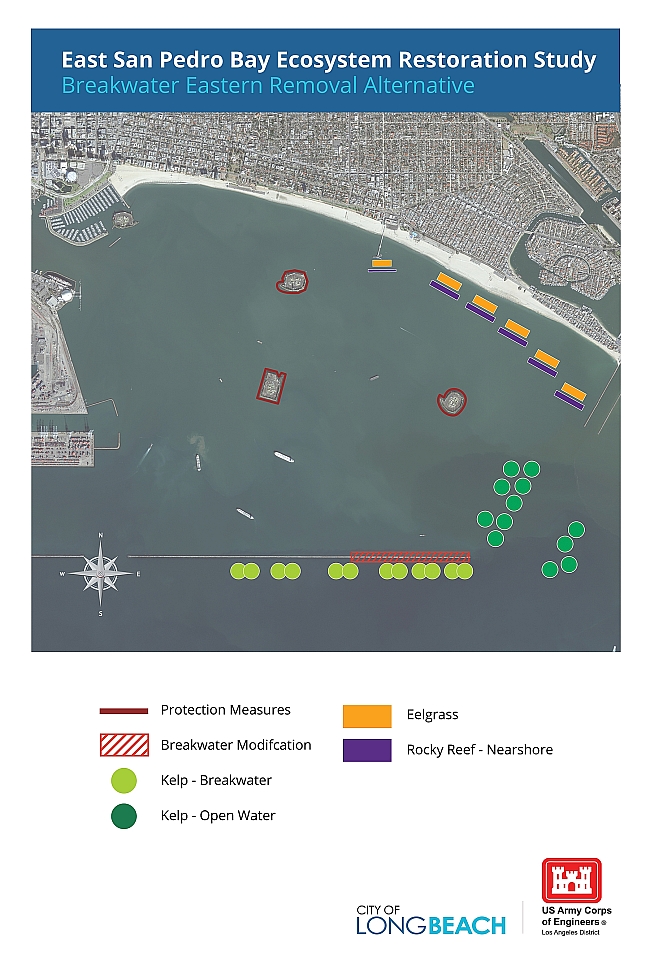
Therefore at the City�s request, the Corps included two breakwater plans into the Preliminary Array of Alternatives. The first breakwater plan they requested includes a measure to remove two 1,000' notches on the west side of the breakwater. This is referred to as the Breakwater Western Notching Plan Alternative BW1). The second plan calls for a measure to remove one-third of the eastern end of the
33 breakwater, referred to as the Breakwater Eastern Removal Plan (Alternative BW2).
The two breakwater measures cannot be combined in the same plan and must be in separate plans.
However, breakwater measures on their own do not meet the plan evaluation criteria of "Completeness" in that they fail to support the Study objective to restore sensitive habitat types.
Because the Study focus is ecosystem restoration, the breakwater measures are coupled with restoration features in order to meet Study objectives. The City agreed to pair the breakwater measures with Best Buy Plan restoration features, which minimally supports the restoration objectives. In addition, to minimize potential induced coastal storm damages, the two breakwater plans include an
additional measure (not included in Best Buy Plan 2), adding one rocky reef shoal in the Near shore Zone.(Page 4-30)
The Corps said the Breakwater Notching proposal would require protective measures:
Protective Measures: Under this alternative, protective measures would be needed to limit the impacts from increased wave energy on existing infrastructure. The increase of wave heights may cause additional damage to the existing revetments from Pier J to the Queen Mary and near Shoreline Marina.
To reduce the risk of failure, the revetments should be rehabilitated to withstand the new wave climate with only minor maintenance over the structural life. For this Study, the rehabilitation of the revetments was used to account for total project costs.
Protective measures would include increasing the amount of protection (armoring) of the existing oil islands and Pier J (see green lines on Figure 4-25). This would be accomplished by placing a second layer of larger stone along the existing slopes of the oil islands. A cast-in place concrete parapet wall would also be added on top of the revetment to protect against excessive overtopping. The near shore rocky reefs would be required to increase in elevation to provide for a similar level of protection against run up and erosion from Calamitous Bay to Belmont Pier and Juniper Beach. A small emergent breakwater, about 10' above water level, would be created to protect Belmont Pier from increased wave energy. Increases in wave heights as a result of Alternative BW1 alters the longshore sediment transport in the area of Junipero Beach and adjacent areas (but not as to threaten other structures). The increase in wave heights are not anticipated to cause damages from overtopping along the shoreline, but would increase the longshore transport rates to a point where the parking lot will begin to be undermined within 10-15 years without any additional action. An offshore submerged breakwater will decrease the incident wave energy thus reducing the local sediment transport and protecting the existing infrastructure.
Protective measures described above mitigate infrastructure damage impacts but not navigation operations impacts. The cost of such additional mitigation features, as well as any costs associated with increased transportation costs which may result from navigation impacts, are not included in the cost estimate for this alternative.
Regarding the possible removal of 1,000 feet from the eastern breakwater, the Corps EIS stated:
Under this alternative, protective measures would be needed to reduce impacts to existing infrastructure and shoreline development from increased wave energy and coastal flooding. These would require increasing the amount of protection (armoring) of the existing oil islands and the creation of a small emergent breakwater to protect Belmont Pier. Additionally, the nearshore reefs
would need to be constructed to a higher elevation to achieve a similar level of protection as the existing Long Beach Breakwater to the shorefront structures and limit excessive shoreline erosion along East Beach. Protective measures described above mitigate infrastructure damage impacts but not navigation operations impacts. The cost of such additional mitigation features, as well as any National
Economic Development costs associated with increased transportation costs which may result from navigation impacts, are not included in the cost estimate for this alternative.
The federal EIS process now invites public comment on the Corps' chosen alternatives (which focus on restoring eel grass and Rocky Reef
Support really independent news in Long Beach. No one in LBREPORT.com's ownership, reporting or editorial decision-making has ties to development interests, advocacy groups or other special interests; or is seeking or receiving benefits of City development-related decisions; or holds a City Hall appointive position; or has contributed sums to political campaigns for Long Beach incumbents or challengers. LBREPORT.com isn't part of an out of town corporate cluster and no one its ownership, editorial or publishing decisionmaking has been part of the governing board of any City government body or other entity on whose policies we report. LBREPORT.com is reader and advertiser supported. You can help keep really independent news in LB similar to the way people support NPR and PBS stations. We're not non-profit so it's not tax deductible but $49.95 (less than an annual dollar a week) helps keep us online.