After LB High Tide Heightened By Baja Hurricane Overtops Peninsula Protective Sand Berm, Does That Change Your Views, And If So In What Ways And Why, Re Modifying LB Breakwater (Incl. Removing Eastern Third)?
LBREPORT.com is reader and advertiser supported. Support independent news in LB similar to the way people support NPR and PBS stations. We're not non-profit so it's not tax deductible but $49.95 (less than an annual dollar a week) helps keep us online.
(Oct. 6, 2018, 2:20 p.m.) -- As LBREPORT.com reported in real time with VIDEO below, an unexpected turn in Hurricane Sergio off Baja California, coinciding with a fairly regular high tide (not a "King Tide") resulted in overtopping the roughly 7 foot high protective sand berm along the Peninsula (with overtopping mainly eastward of 61st Place, most visible around 64th Place.) See LBRPEORT.com VIDEO coverage of what happened as a result of the Hurricane-heightened morning and evening high tides on Oct. 5.
The morning video includes on-scene comments of 3rd dist. Councilwoman Suzie Price, who urged those supporting the return of waves to see for themselves what happened. The evening high tide video at 64th Place shows the beach has basically disappeared, filled by the ocean, with waves overtopping the berm and knocking against, and in some spots penetrating, gaps in wood planks hurriedly installed with temporary struts while heavy equipment worked to bolster the sand berm.
[Scroll down for further.]
So does this change your view, and if so in what way(s) and why -- toward the "Eastern Removal Alternative" that would remove roughly one third of the eastern end of the LB Breakwater? Let us know via Facebook or our Disqus comment system, below.
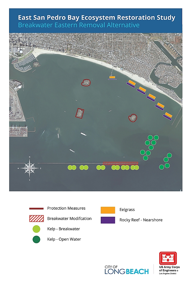
Removing the eastern third of the Breakwater is one of two potential Breakwater modifications that will be studied by the U.S. Army Corps of Engineers among potential projects for ecosystem restoration in Eastern San Pedro Bay. The other Breakwater modifying alterative would creating notches in the western end of the LB Breakwater; see details in LBREPORT.com coverage here and here)
Sponsor
Sponsor
The following text and graphics are from a Corps of Engineers "Draft Wave Modeling Summary" (dated Aug. 28, 2018):
Eastern Removal Alternative: Would remove one third (24 acres) of the eastern end of the current LB Breakwater. Mayor Garcia said preliminary wave modeling indicates this would have impacts on LB's oil islands, possibly Belmont Pier and issues involving the Navy's use of its explosives anchorage in Seal Beach. The Mayor likewise said "we're looking at whether stones removed from the Long Beach breakwater could be used to build mitigation measures and this includes protective structures around the oil islands, the Belmont Pier, and of course we are working with our Navy partners." Mayor Garcia revealed that "just a few weeks ago, I met with the Navy and the top leadership...over here at the Navy base to discuss this measure and to work together in partnership as we move forward. Additionally, higher elevation near-shore rocky reefs will be added to mitigate the impacts to the Peninsula and to adjacent infrastructure."
BREAKWATER MODIFICATION
Under this Breakwater Plan, approximately 1/3 (approximately 24-acres) of the existing Long Beach Breakwater would be removed. Stones removed from the breakwater would be reused to build protective structures around the Oil Islands and Belmont Pier only. Armoring methods for these features would be as described for the Alternative BW1.
PROTECTIVE MEASURES
Under this alternative, protective measures would be needed to reduce impacts to existing infrastructure and shoreline development from increased wave energy and coastal flooding. These would require increasing the amount of protection (armoring) of the existing oil islands and the creation of a small emergent breakwater to protect Belmont Pier. Additionally, the near shore reefs would need to be constructed to a higher elevation to achieve a similar level of protection as the existing Long Beach Breakwater to the shorefront structures and limit excessive shoreline erosion along East Beach.
ADDITIONAL NOTES
Impacts to the Port of Long Beach, the Navy and other navigational interests resulting from the Breakwater Eastern Removal Plan remain under analysis. Measures to reduce or mitigate for these impacts are also under development. Those impacts and potential mitigation measures would be more thoroughly presented in the Draft IFR/EIS-EIR.
Slight modifications from Alternative 2 are the same as described above.
For NEPA (National Environmental Policy Act) analysis purposes, the team is currently reviewing the compatibility of breakwater modification measures to the other best buy plans, Alternative 4 and Alternative 9.
Sponsor
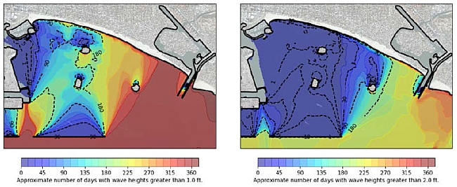
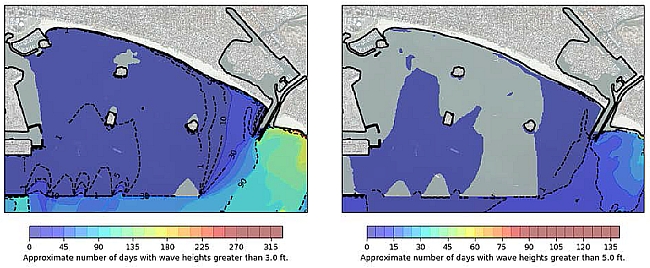
Removal of eastern 1/3 of the Breakwater
The four graphics, left to right, row to row, show the approximate number of days with wave heights greater than 1 ft, 2 ft, 3ft and 5 ft.
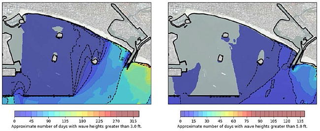
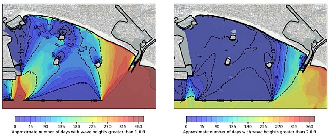
Creating two 1,000 ft. notches in western end of the Breakwater
The four graphics, left to right, row to row, show the approximate number of days with wave heights greater than 1 ft, 2 ft, 3ft and 5 ft.
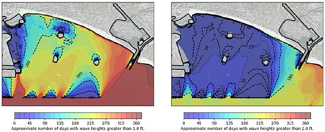
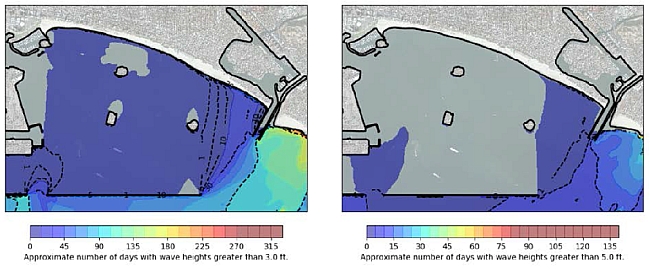
Comparison to current (no project) conditions
The four graphics, left to right, row to row, show the approximate number of days with wave heights greater than 1 ft, 2 ft, 3ft and 5 ft.
Sponsor
Sponsor
Support really independent news in Long Beach. No one in LBREPORT.com's ownership, reporting or editorial decision-making has ties to incumbent Long Beach officials, development interests, advocacy groups or other special interests; or is seeking or receiving benefits of City development-related decisions; or holds a City Hall appointive position; or has contributed sums to political campaigns for Long Beach incumbents or challengers. LBREPORT.com isn't part of an out of town corporate cluster and no one its ownership, editorial or publishing decision making has been part of the governing board of any City government body or other entity on whose policies we report. LBREPORT.com is reader and advertiser supported. You can help keep really independent news in LB similar to the way people support NPR and PBS stations. We're not non-profit so it's not tax deductible but $49.95 (less than an annual dollar a week) helps keep us online.