See How And Where City Staff Proposed Land Use Revisions Could Invite Higher Commercial And Residential Densities In Parts Of Low Density East Long Beach
LBREPORT.com is reader and advertiser supported. Support independent news in LB similar to the way people support NPR and PBS stations. We're not non-profit so it's not tax deductible but $49.95 (less than an annual dollar a week) helps keep us online.
(Feb. 1, 2017, 10:25 p.m.) -- As LBREPORT.com previously stated: it's big, could affect properties and neighborhoods citywide...and as we show below, that includes quiet ELB.
On Thursday Feb. 2 at 5:00 p.m., LB's non-elected (Mayor chosen, Council approved) Planning Commission will hold a hearing, take public testimony, discuss and possibly make changes, and vote to send to the City Council proposed changes to a complete revision of the way Long Beach City Hall treats land uses citywide. City staff proposes an entirely new Land Use Element (LUE) and an entirely new Urban Design Element to LB's General Plan.
Changes in the city's Land Use Element invite future changes to the city's zoning (which is supposed to be consistent with the Land Use Element.) These changes could create economic incentives for projects and developments that, over time, could change the area's residential and commercial densities.
The changes wouldn't happen overnight; they might be subtle at first, occurring in some areas but not others; they might not happen, or if they do, they might be years away. But once City Hall makes the changes, the process would be driven by economics. By increasing allowable land uses, City Hall would create economic incentives for more intense residential and commercial uses and developments.
[Scroll down for further.]
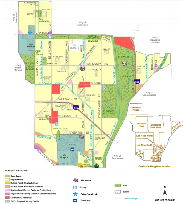
For example, in current low-density East Long Beach, the newly proposed Land Use Element classifies the sprawling residential area (stretching from basically Lakewood Blvd/Clark Ave. to the eastern city limits, and from Atherton St. to Carson St.) as a "Founding and Contemporary Neighborhood" Placetype.
PlaceTypes, Draft Land Use Element, p. 149
Its narrative text describes this PlaceType for "single family and low density housing" but an accompanying table listing "PlaceType, Density and Intensity Levels (p. 65) indicates that it would allow residential densities ranging from 7 dwelling units per acre up to 18 dwelling units per acre.
For a rough idea of what 18 dwelling units per acre might look like, consider that the controversial "Riverwalk" residential development (allowed by the Council on the former Will J. Reid scout park site) sought only roughly 13 dwelling units per acre and the Crown Point development built in the late 1970s in the 7th district near Los Cerritos Park allowed a bit over 14 dwelling units per acre. [We presume allowing up to double-digit residential densities may be meant to invite townhouses or the like, depending on future zoning.]
The text narrative describing the "Founding and Contemporary Neighborhood" PlaceType likewise invites density by proposing "appropriately scaled multi-family structures" at "neighborhood edges, transitions and key intersections..." [LUE, p. 75]
[Founding and Contemporary Neighborhood Placetype] Land Uses and Development Standards. This PlaceType
encourages low-density housing at one or two stories in height, along with appropriately scaled multi-family structures, compatible public facilities and small-scale neighborhood serving commercial uses. This PlaceType prohibits incompatible, large-scale multi-family structures, as well as other uses that would detract from the established architectural character of the neighborhood. Preferred uses
and development standards include:
Single-family and low-density housing (7 - 18 units/acre)
Typical population density is 20 - 51 persons/acre
Schools, parks, daycare, senior care, police and fire stations, libraries, and other compatible public uses
Buildings are limited to two stories in height (28 feet maximum), or three stories consistent with MAP LU-7.
Development Pattern. This PlaceType promotes maintaining single-family homes while allowing neighborhood edges, transitions and key intersections to have appropriately scaled multi-family structures, public facilities and small-scale neighborhood-serving
commercial uses.
Transitions. Transitions work to integrate the neighborhood with surrounding land uses in a manner that reinforces the established fine-grained character. New multi-family buildings will be designed to reflect the characteristics of single-family homes to allow for better integration. All new development will respect the height, massing and open space characteristics of the
neighborhood.
Access. Steps should be taken to better connect all neighborhoods to the larger transit network, provide better bicycle connections and facilities, and focus on pedestrian activity and sidewalk/streetscape improvements that will make all neighborhoods enjoyable, easy places to walk.
Parking. Generally, standard parking requirements will be applied to new development. However, the City may allow reduced parking where appropriate to encourage retention of historic and cultural resources and/or to promote transit usage. Consistent with the City's sustainable development goals, use of permeable paving and preservation of landscaping and yard areas will help capture water on-site and manage urban runoff . On-street parking and other tools will be used to help calm traffic on excessively wide streets.
[Comment: Do ELB residents want to allow reduced parking requirements "to promote transit usage?" Or to have the city use "tools" to "calm traffic" on "excessively wide streets?]
The "Placetype, Density and Intensity" table on p. 65 indicates that the maximum allowable residential height is "2 stories, 28 feet" but a footnote states that: "Height may be increased to three stories as shown on MAP LU-7 consistent with the existing land use pattern." [Much of ELB's current R-1 type zoning allows up to two stories plus an added two feet for stair access to the roof.]
Sponsor
Sponsor
Meanwhile, in ELB's commercial nodes, the new Land Use Element proposes to allow three story commercial buildings instead of the area's current mainly-low-rise commercial buildings at Spring/Woodruff/LCD, Spring/Palo Verde, Spring/Bellflower, and the Los Altos shopping center along Bellflower Blvd. north and south of Stearns St. and the ELB Carson St. Towne Center. [Source: Eastside Placetype Maps pp. 66-67 (legend on p. 67) plus the "PlaceType, Density and Intensity Levels" p. 65, with footnoted text indicating maximum height limits can vary; p. 65 refers to Map LU7 but the Land Use Placetype Height Limits appear on Map LU8 p. 68 which indicates the height limits could reach three stories.]
The areas in purple on the PlaceType map -- the shopping areas at Spring/Woodruff/LCD and Wardlow/LCD/Palo Verde -- are designated as designated as "Neighborhood-Serving Centers and Corridors -- Low" and described as "low-rise, low-intensity mixed use (housing and retail) commercial centers and corridors designed to meet consumers� daily needs for goods and services close to residential areas (see Map LU-11). Ideally, residents could walk to these locations for shopping, personal services or dining. This PlaceType applies to locations where shopping combined with low-density housing is desirable from both a land use and mobility perspective. This is frequently the case at major street intersections and/or along established neighborhood shopping corridors, particularly where these corridors are served by transit." [LUE, p. 80]
Are the following "Preferred uses and development standards" what ELB residents want for Spring St./Woodruff/LCD and Wardlow/LCD/Palo Verde?
Low-density apartment and condominium buildings (6 units/lot, 44 units/acre maximum).
Typical population density is up to 125 persons/acre.
Schools, parks, daycare, senior care, police and fire stations, libraries and similar facilities.
Buildings not to exceed three stories in height (38 feet maximum). [LUE, p. 80]
And the Placetypes in red -- the "Plaza" at Spring St./Palo Verde, the SE commercial center at Bellflower/Spring St., the Los Altos Shopping Center (along Bellflower, both sides of Stearns St.) and ELB Towne Center -- are described as "Community Commercial" meant to encourage "a wide range of local and community-serving commercial uses in buildings [limited to three stories at these locations]...These may include auto sales and repair, appliance sales and repair, furniture stores, hardware stores, clothing stores, restaurants, grocery stores, fast-food outlets and similar uses. Preferred uses and development standards include:
Commercial uses that serve community-based needs for goods and services (0.25 - 1.0 FAR).
No residential uses are allowed...
Overall, City Hall's planners have the following in mind for ELB:
[Proposed Land Use Element, Eastside, Issues/Needs, pp. 147-148] . The Eastside of Long Beach is well-served by schools, libraries, police and fire facilities. Recreation open space in the community is abundant, although more neighborhood-focused park space is desirable as much of the existing public open space is devoted to golf and sports fields. Another issue in recent years is the mansionization of single-family homes and the over-development of parcels, which have left little open space. Needed are greater design controls and higher standards to ensure that remodels of existing homes and insertions of new developments are attractive, composed of quality materials, and compatible with neighboring uses and structures. Although shopping opportunities are fairly good for Eastside residents, most centers are too far to walk to for the majority of people and are highly automobile-oriented in design. Vehicular traffic moves well throughout the area; however, it is often at the expense of other modes of travel, namely pedestrians and bicyclists. In the future, a better multi-modal balance is called for. Traffic will need to be calmed and controlled so residents feel safe to walk or ride their bicycles for short trips or daily exercise. Also detracting from East Long Beach walkability and attractiveness is the lack of street trees along many streets. Many need to be replaced due to the age of the trees.
[Comment: Do eastside residents (including those who object to the green "bollards" along part of Studebaker Rd) want traffic "to be calmed and controlled so residents feel safe to walk or ride their bicycles for short trips or daily exercise?"]
Land Use Strategies.
1. Provide vigorous code enforcement to protect the housing stock and prevent deterioration of the neighborhoods.
2. Develop new single-family design guidelines and standards to implement the Contemporary Neighborhood PlaceType.
3. Develop new design guidelines and standards to implement the Neighborhood Serving Centers and Corridors (horizontal and vertical mixed use of low and moderate density) PlaceTypes.
[Comment: Do eastside residents want "horizontal and vertical mixed use" [which we interpret to mean commercial combined with residential developments] in "Neighborhood Service Centers and Corridors" at Spring/Woodruff/LCD and surrounding Wardlow/LCD/Palo Verde?]
4. Direct future multi-family development to existing locations and locations served by public transit, especially near regional-serving sites.
5. Improve streetscapes and the design of commercial sites to promote greater walkability in commercial activity centers and shopping nodes that are adjacent to residential neighborhoods.
6. Maintain public services and facilities and continue providing locations for schools, parks, libraries, public safety, shopping and other community-serving uses.
7. Continue to support the regional-serving missions of Long Beach City College, CSULB, the Veteran's Administration Medical Center, and employment opportunities near the airport. Require master plans to ensure quality development and improved community-connectivity for each of these areas.
8. Seek opportunities to create additional neighborhood-serving recreation open space, community gardens and other green areas. Study and plan for possible future recreation opportunities along the Los Cerritos Drainage channels, at public and private school recreation facilities, under utility line corridors and on remnant parcels of land that should not be developed with buildings.
9. Continue to work closely with the San Gabriel River and Mountains Conservancy and others to protect, restore and enhance the San Gabriel River and Coyote Creek and their recreation and wildlife amenities.
10. Finish the City's urban forestry inventories then develop and implement tree planting, maintenance and greening plans which are coordinated with citywide air quality improvement (greenhouse gas reduction) and local water-saving landscape plans and programs.
11. Keep providing economic incentives for people to convert high-water consumption landscapes to water-saving landscapes such as native and low-water gardens.
12. If the Los Angeles County island of homes and businesses between Woodruff and Palo Verde avenues is annexed into the City, consider designating the properties as Contemporary Neighborhood PlaceType.
13. Over time, transform East Long Beach into a much more pedestrian and bicycle friendly community by planning and implementing safe and efficient walking, bicycling and transit access and connectivity within neighborhoods and to the surrounding community. Implement Mobility Element capital improvements for East Long Beach, including:
Improve the transit hub at CSULB.
Develop a new transit hub at the City College.
Reconfigure Studebaker Road at the I-405 Freeway to improve access and reduce neighborhood intrusion.
Make freeway entrance improvements at Studebaker Road and 7th Street.
Make intersection improvements at Bellflower Boulevard and Stearns Street, Bellflower Boulevard and Atherton Street, Palo Verde Avenue and Stearns Street, and at the Los Coyotes Diagonal where it meets Studebaker Road and Carson Street.
� Make signal improvements at Atherton Street and Palo Verde Avenue.
Make improvements to Spring Street and the I-605 Freeway ramp to improve freeway access and reduce neighborhood intrusion
Widen the Spring Street Bridge over the San Gabriel River.
Make bicycle facility improvements per the Bicycle Master Plan. [More green bollards?]
Sponsor
Sponsor
And that's just for ELB. Other sections of the proposed new Land Use Element and accompanying Urban Design Element describe City Hall staff's plans for neighborhoods citywide.
All of this is coming to the Feb. 2 Planning Commission hearing. The public can voice their views on the proposed changes, pro or con now and when this reaches the City Council in the coming weeks or months when a Council majority will ultimately decide.
And that Council vote will in many ways decide the future for many of LB's neighborhoods.
LBREPORT.com will provide LIVE VIDEO of Thursday's Planning Commission meeting on our front page -- www.LBREPORT.com. Scheduled start time is 5:00 p.m. Thursday, Feb. 2.