City Hall's Hired Consultants To Offer Their SEADIP (SE LB Zoning) Re-Write Recommendations -- Proposed Changes Potentially Affecting Future Of Commercial Development And Open Space In SE LB -- At 5 p.m. Planning Comm'n "Study Session"
LBREPORT.com is reader and advertiser supported. Support independent news in LB similar to the way people support NPR and PBS stations. We're not non-profit so it's not tax deductible but $49.95 (less than an annual dollar a week) helps keep us online.
(May 21, 2015) -- City Hall's hired consultants will offer their recommendations today (May 21) on a very big ticket item: a re-write of SEADIP master plan zoning governing the future of commercial development and open space in a major chunk of SE LB.
This will take place at a 5 p.m. study session (public meeting but no voted action planned) of LB's Planning Commission in City Hall's Council Chamber, 333 W. Ocean Blvd. LBREPORT.com plans to webcast the proceedings live.
[Scroll down for further.]
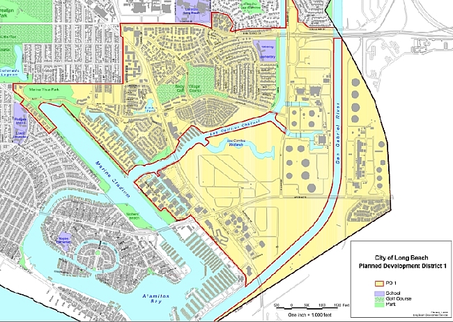
Current SEADIP zoning map
A City Hall release states that the "conceptual land use plan reflects the collaborative efforts of the community and the Community Advisory Committee (CAC) to comprehensively review and update a 1,500-acre area of Southeast Long Beach known as SEADIP. The three-year planning process includes extensive community outreach efforts, consisting of pop-up events, interactive workshops, and community meetings."
However veteran wetlands and coastal protection advocates who attended and have been taking part in the meetings, have been watching the developing draft results with some concern.
[Scroll down for further.]
Advertisement
Advertisement
Following the consultants' presentation on a draft plan at a Feb. 2015 "community workshop," (LBREPORT.com coverage at this link), coastal area protection advocate Gordana Kajer commented:
I am very dismayed when I see a draft plan, presented in public, that shows an extension of Shopkeeper Road, when in fact we know, and the public has been advised, that a road through wetlands is not allowed under the Coastal Act. When the City of Long Beach promotes this information as a means for traffic mitigation, obviously something that they promote and describe to the community about this road, it�s presumably to help with traffic. But you can't put a road there. So when you see this kind of information promoted as a fact, in a beautiful presentation to the public by consultants and city staff, in a public process to facilitate information and opinions, the legitimacy other information being presented as "fact" to the public in this meeting may need to be questioned as well.
Environmental advocate Ann Cantrell said:
It seems to be geared towards the developers with very little concern for the wetlands. I'm most concerned that they seem to be saying that it is going to have to be at least five stories high, the buildings, to be financially feasible, and I would like the height limits of three stories to remain, and a lot of people here tonight have voiced that same concern."
And Elizabeth Lambe, Exec. Dir. of the Los Cerritos Wetlands Land Trust, told LBREPORT.com, "I certainly would urge the people running this planning process to consult early and with a great deal of specificity with the Coastal Commission so what ever they are planning is keeping with the Coastal Act. There are aspects of the current plan that seem to me may not be legal under the Coastal Act.
The Los Cerritos Wetlands Land Trust states on its website:
We have said it before and are saying it again: we are glad that the zoning for the areas in and around Los Cerritos Wetlands are being updated. The current zoning is so old and out-of-date it does not reflect what we now know about the fragility and importance of wetlands. Current SEADIP zoning is from the '70s, when things like roads through wetlands, development on wetlands, and industrial construction on the coast seemed reasonable. Thankfully, those days are long gone.
There is a lot to take into consideration when thinking about the best way to plan for the future of South East Long Beach, but first and foremost must be the protection and stewardship of Los Cerritos Wetlands. Thankfully the community seems to agree, or at least that is my impression after attending the community meetings about the SEADIP update. But what does the stewardship and protection of Los Cerritos Wetlands mean exactly? How does one go about ensuring that whatever is planned for the lands in and around Los Cerritos Wetlands, protection of wetlands has the highest priority?
Well we didn't know ourselves exactly, so back in 2013 when the SEADIP updating process was just beginning we commissioned a review from the respected ecological consulting company Tidal Influence. After doing research and assessing what data was already available to help guide the biological review process, Tidal Influence's Report recommended the following studies and analysis be incorporated into the SEADIP updating process: Wetlands Habitat Buffer Analysis, specifically in the areas of light, noise, runoff and human use, Wildlife Corridor Analysis, with a focus on bird trajectory and mammal tracking. And lastly, Comprehensive Habitat Quality Assessment.
We hope that is all this information is being looked at and considered by the folks running the SEADIP updating process. As one community member put it, "It would be a loss for our community if Long Beach's iconic big blue herons that fly so gracefully between Los Cerritos Wetlands and Alamitos Bay were no longer able to do so because of too tall buildings." He is expressing concern about the proposed up-to-7 story structures that will possibly be part of the new SEADIP. I [LCWLT Exec. Dir. Elizabeth Lambe] look forward to having those sorts of concerns being addressed at the Planning Commission's SEADIP Update Study Session.
[Scroll down for further.]
Advertisement
Advertisement
In response to traffic concerns voiced at the Feb. 2015 public meeting, the consultants said a traffic analysis would be available later in the SEADIP process. However, as previously reported by LBREPORT.com, at the October 2014 meeting of SEADIP's Advisory Committee at which the four development scenarios were originally presented, the consultant consortium's traffic engineer, Jason Pack, did present traffic figures on the four scenarios.
Traffic engineer Pack reported in October 2014 that SEADIP's current 119,934 daily trips would increase from 2% to 5% for each development in the possible four scenarios. Specifically, traffic engineer Pack reported that for each Scenario One development in the area, 2% more daily trips would be added to the current total; each Scenario Two mixed-use development built would add 1% more total trips; every Scenario Three project built would add 3% more daily trips; and every Scenario Four project built would add 5% more daily trips to the current total.
Under the fourth scenario (which the consultants presented as the most economically feasible), the October traffic figures indicated that five Scenario Four developments within the SEADIP area would add 25% more traffic or 29,983 more daily trips to the area.
[Scroll down for further.]
Advertisement
Advertisement
Following today's Planning Commission study session, LB's Planning Commission non-elected (Mayor-chosen, Council approved) will take required public testimony, and then can approve, tweak, amend and ultimately vote on the consultants recommendations in forwarding them to the City Council. The Council, after required public testimony, will vote on the final shape of the SEADIP zoning. Its decision will be reviewed by the CA Coastal Commission on Coastal Act issues.
Further to follow.
Disclosure: The Los Cerritos Wetlands Land Trust has an informational ad spotlighting its monthly walks through the wetlands area running on LBREPORT.com.