City Staff Has Issued New Draft Maps Showing Belmont Shore 2nd St. Heights At Two Stories, And PCH From Loynes to Seal Beach As "Regional Serving Facility" Without Indicated Bldg Height(s), Stressing Maps Are Drafts For Public Input/Discussion At Oct. 1 Planning Comm'n Meeting And Beyond
LBREPORT.com is reader and advertiser supported. Support independent news in LB similar to the way people support NPR and PBS stations. We're not non-profit so it's not tax deductible but $49.95 (less than an annual dollar a week) helps keep us online.
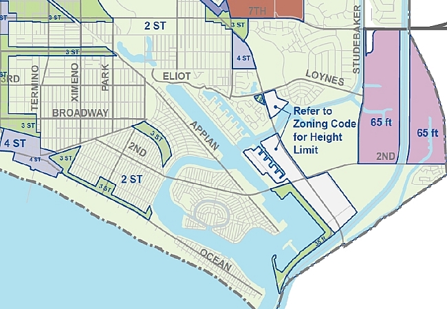
(Sept. 28, 2015) -- At some point after July Belmont Shore resident Melinda Cotton alerted LB's Planning Commission to a 179 page General Plan update showing increased commercial building heights in Belmont Shore and along PCH in SE LB, city staff produced [we believe in September] a new draft map for Council dist. 3 that shows Belmont Shore with commercial building heights along 2nd St. at two stories, four stories near the Belmont Pier and commercial areas along PCH from Loynes to the Seal Beach city line called a "regional serving facility" without specific building height(s) indicated.
In addition, city staff has issued an updated version of the 179 page proposed General Plan revision, dated Oct. 1, 2015...which includes a significantly revised "Placetype height Limits" map, which LBREPORT.com also displays and linke below.
Some of these documents have only fairly recently appeared online [we believe at some point in September, but we're not certain exactly when.] City staff says the new maps are proposed for discussion at the Oct. 1 Planning Commission study session...and are drafts, not set in stone.
[Scroll down for further.]
Below is a zoomed-in portion of the revised height limit map for the Belmont Shore/SE LB area in the updated (Oct. 1) 179 page General Plan document. 2nd St. isn't indicated for change; PCH between Loynes/Seal Beach line is indicated as "Refer to zoning code for height limit."
Source: UPDATED "Placetype Height Limits," p. 67, "Draft Land Use Element," Published by City of Long Beach, Oct. 2015
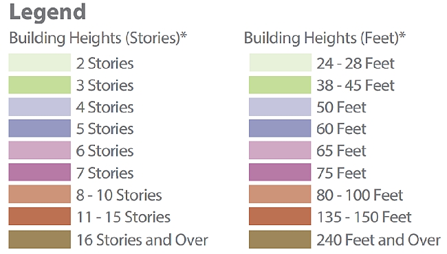
Legend accompanying map cited above
In a mass emailing sent at midafternoon Monday (Sept. 28), 3rd dist. Councilwoman Suzie Price stated:
Please view the current map [image below, map click here.] which is just a starting point for discussions. I am very sensitive to concerns regarding the proposed height increases and know that I am committed to listening to those concerns as well as looking at each particular neighborhood to determine if a height increase is appropriate based on the characteristics of each neighborhood. I look forward to a process that is open and collaborative, therefore please provide your input by either attending the Planning Commission Study Session or by contacting me directly through email at district3@longbeach.gov or by phone at (562) 570-6300. I thank you in advance for participating in the discussions, it is informed residents like you that truly make a difference in our community!
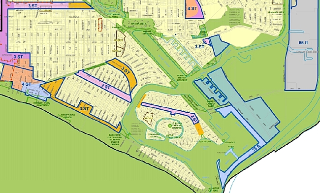
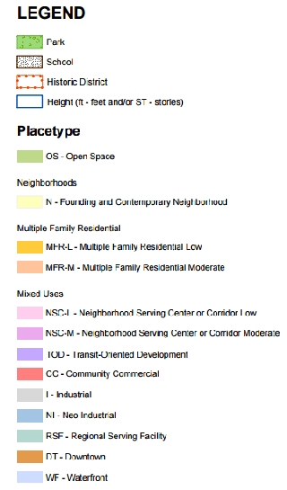
Portion of map attached to Councilwoman Price's Sept. 28 email. For pdf, click here.
The General Plan land use revision document contains more than one map; it contains several, a well as charts and other explanatory materials describing city staff-favored land use changes citywide. These are visible in the document at this link.
A City Hall "e-notify" message (on Friday Sept. 25 in the 3 p.m. hour) tells recipients the City is "in the process of updating its General Plan, and the public is invited to attend a second Planning Commission Study Session and learn more about the City's vision for future land use and urban design in Long Beach."
The proposed land use changes could impact neighborhoods in differing degrees and in different ways across Long Beach. We recommend residents and their neighborhood groups to examine city staff's proposed "placetype" maps at this link AND the city-prepared brochure (General Plan revise) includes several maps showing proposed land use changes and other matters at this link.
[Scroll down for further.]
Advertisement
Advertisement
LBREPORT.com is informed and believes that on Oct. 1, city staff plans to offer a Power Point presentation to the Planning Commission that will basically indicate various "placetypes" envisioned for various parts of the city for a 20 year time span. The presentation will include an estimated schedule of major milestones including the forthcoming release of a draft land use element and a Draft EIR [Environmental Impact Report.]
The non-elected Planning Commission (members Mayor chosen, Council approved) can make voted recommendations, but the City's ultimate policy-setting body (on land uses and other matters) is the elected City Council.
Scroll down for further
Advertisement
Advertisement
Perspective
Changing LB's current height limit in the coastal zone is subject to Coastal Commission approval. Protecting SE LB's current low rise/low commercial density (accepted years ago as a trade-off for allowing greater heights and density downtown) has been a continuing struggle for area residents. Commercial property owners and development interests predictably seek higher commercial building heights in their own economic interests.
As previously reported by LBREPORT.com, in 2013 the state Senate Rules Committee (in a non-transparent proceeding closed to the public and the press) chose then-voting Vice Mayor/Councilmember Robert Garcia to fill an interim Coastal Commission vacancy, later extended to a full Coastal Commission term, but lost that position under current law when he became LB's non-voting Mayor. Since then, Garcia's allies (prominently state Senator Ricardo Lara) have sought to change state law to enable Garcia (and other non-voting Mayors) to gain positions on the powerful land use body that controls coastal development permits statewide.
SB 798, currently awaiting Governor's Brown signature, deals mainly with fish and game matters but has Coastal Commission verbiage inserted that would enable Councilman Roberto Uranga -- appointed to the Coastal Commission in early 2015 by the state Senate Rules Committee in the same non-transparent manner as Garcia -- to name Garcia as his voting alternate...and Uranga has publicly stated he intends to do so when legally able.
Although Councilman Uranga (who took office in mid-2014) hasn't had occasion to vote as a Councilmember on contentious proposed LB coastal area developments that seek increased heights, Garcia has...and did. In December 2011, a Council majority voted down a proposed mixed use development at 2nd St./PCH (Seaport Marina hotel site) citing multiple issues including a request to allow building heights beyond the 35 feet now allowed in LB's Coastal zone. The Council vote was 3-5 to reject the proposed development...with Garcia among those voting to approve it. [Yes: Garcia, DeLong, Gabelich; No: Lowenthal, O'Donnell, Schipske, Andrews, Neal; Johnson absent.]
Advertisement
Advertisement
Developing...with further to follow on LBREPORT.com.