Hurricane "Surge" + High Tide Bring Some Seawater Over/Thru Part Of Peninsula Sand Berm, Flows Onto Part of Ocean Blvd. (LBFD Says Roughly Curb Level, Only Ocean Side of Street) b/w About 55th-57th Pl.; Crews Divert Flow, Reinforce Berm, Remain Watchful Until Pacific Hurricane Passes
(Aug. 27, 2014, 4:40 a.m.) -- The combination of a passing Pacific hurricane "surge" and an evening high tide sent some seawater over or through part of the western portion of a Peninsula sand berm, sending water past sand and onto the ocean side of Ocean Blvd. between roughly 55th Place to 57th Place, reaching roughly curb level before dissipating into storm drains
[Scroll down for further]
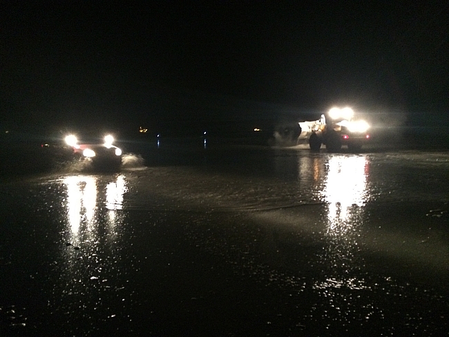
Photo via Jake Heflin, PIO/LBFD
Photo via Jake Heflin, PIO/LBFD
LBFD Public Information Officer / Firefighter Jake Heflin says the impacts between roughly 11:00 p.m. and a bit past midnight weren't extensive and to his knowledge didn't get into homes. "There were places where the continued lapping of the sea water that came up to the berm, splashed over or eroded part of the berm," PIO Heflin said. Parks and Rec crews [who by LBREPORT.com's unofficial reckoning had been on scene for over 24 hrs] worked to divert the flow, then built up and strengthened the berm. As the high tide receded, the seawater dissipated through storm drains.
Overnight broadcast reports indicate the impacts were heavier in Seal Beach...which is beyond LB's breakwater.
LB's next high tides today (Aug. 27) are expected at 11:01 a.m. (4.98 feet) and 10:54 p.m. (5.09 feet.) At predawn Aug. 27, satellite images show Hurricane Marie (now weakening) off the Baja Mexico coast on path veering northwest away from CA...but since its "surge" may still pack a punch, LBFD and Parks & Rec crews remain watchful.
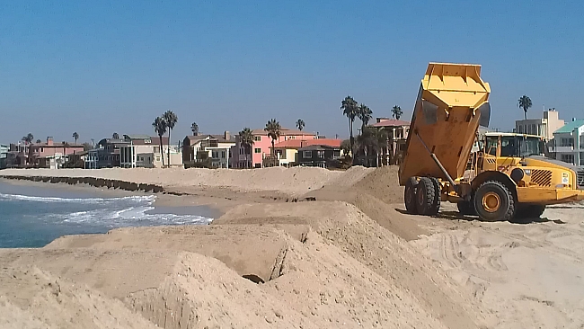
(UPDATED Aug. 26, 11:44 a.m. from initial Aug. 25, 2014) -- Long Beach city officials issued a release with some urgency (text below); city crews worked to build and strengthen a sand berm along the peninsula anticipating a "surge" generated by a large pacific hurricane (Marie) several hundred miles south and headed northwest.
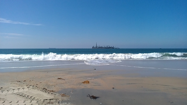
This morning (Aug. 26), LBREPORT.com and multiple Los Angeles market TV and radio outlets were present as the ocean came up to the first seaward "sand wall," stopped short of the peninsula beach itself and (at least in the 10 a.m. hour) didn't come close to the protective large sand berm.
Aug. 26, 11 a.m.
LBFD issued the following advisory at 11:37 a.m.:
City crews have taken significant efforts to prepare for a storm surge on the Long Beach Peninsula from Hurricane Marie located in the Eastern Pacific Ocean.
A coordinated multi-department response will continue throughout the duration of the event. Sand berms have been fortified. Additional staff and equipment have been in place closely monitoring the situation.
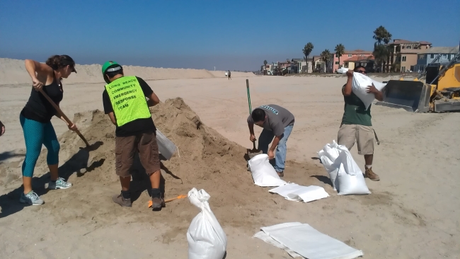
The City is making sand bags available to Peninsula residents. Bins of sand and empty bags are available at Ocean Boulevard and 72nd Place and at the Claremont lot at Ocean Boulevard and Claremont. Residents must bring their own shovels and we ask that residents limit their allotment to 10 sandbags per visit.
Currently there are no impacts from the first anticipated surge event. The berms remain intact and there are no reports of flooding or other problems.
The next anticipated surge event is forecasted for tomorrow, August 27, at 6:00 PM.
CERT crew
The Nat'l Weather Service issued an advisory yesterday (Aug. 25) forewarning cities with south-facing beaches to be ready for large swells bringing very high surf...however other cities don't have a breakwater as Long Beach does. LBREPORT.com saw some surf (approx. 54th Place) but we've seen higher waves and water levels during some local storms.
Aug. 26, approx. 11:00 a.m.
As LBREPORT.com reported in March 2014, storm fed high swells plus a high tide eroded the eastern part of the peninsula berm, sending water cascading onto Ocean Blvd and flooding some garages and parked cars b/w 61st St. and 72nd St. (LBREPORT.com coverage here.
Better safe than sorry...and watchful for the next few days...but this morning (Aug. 26), it was a gorgeous sunny day along LB's Peninsula.
Aug. 26, approx. 11:00 a.m.
(Aug. 25, 2014) -- ...Long Beach city officials are expecting that a Pacific hurricaine will produce a [city release text] "storm surge event with higher than normal water levels" which is expected to impact Long Beach's Peninsula area...and city officials expect it to be "over and above the predicted astronomical tides.
The City Hall release (full text below) explicitly advises Peninsula residents to "take appropriate steps to be prepared for this storm surge event, by securing personal property and vehicles in areas that are prone to flooding along the Peninsula."
Yes, this is even WITH the Breakwater.
Below is the text of the City of Long Beach release:
[City of LB release text] A storm surge event with higher than normal water levels is expected to impact the Peninsula area on Tuesday morning at approximately 10 am and also on Wednesday afternoon at approximately 6 pm. The storm surge is being caused by Hurricane Marie in the eastern Pacific Ocean, and is over and above the predicted astronomical tides.
City crews are preparing for the storm surge with a coordinated, multi-department response by fortifying sand berms, deploying additional staff and equipment to the area around the clock and closely monitoring the situation.
Volunteers from the Community Emergency Response Teams (CERT) and the Long Beach Search and Rescue Explorer Program are distributing fliers to households on the Peninsula in preparation for the storm surge. Residents should take appropriate steps to be prepared for this storm surge event, by securing personal property and vehicles in areas that are prone to flooding along the Peninsula.
The City is making sand bags available to Peninsula residents. Pre-filled sandbags are available at Ocean Boulevard and 55th Place. Bins of sand and empty bags are available at Ocean Boulevard and 72nd Place, and also at Ocean Boulevard and Claremont Avenue. Residents must bring their own shovels and are limited to filling 10 bags.
More information is available at www.longbeach.gov/disasterpreparedness and www.longbeach.gov/fire/cert.
NOAA satellite image shows Hurricane Marie approaching from south, heading northwest, several hundred miles away but still strong enough to bring swells to So. Cal coast. Time of half-hour images is "UTC" = 7 hours ahead of PDT (so subtract seven hours for local time.)
The National Weather Service has issued the following "high surf advisory." Yes, its text mainly affects coastal areas that (unlike LB) don't have a Breakwater, but as LB locals know, Pacific storms can produce waves and swells in LB (attenuated compared to other areas) even WITH the Breakwater. Below is the Nat'l Weather Service High Surf Advisory as of 12:10 p.m. Aug. 25:
[Nat'l Weather Service uses all caps] -- SURF FROM HURRICANE MARIE IS EXPECTED TO BUILD RAPIDLY ALONG EXPOSED SOUTH FACING SHORES ON TUESDAY. THE SURF WILL PEAK LATE TUESDAY NIGHT THROUGH WEDNESDAY AND PERSIST THROUGH THE REMAINDER OF THE WEEK. THERE IS THE POTENTIAL FOR DAMAGING AND LIFE THREATENING SURF ACROSS SOUTH AND SOUTHEAST FACING SHORES OF LOS ANGELES AND VENTURA COUNTIES. THESE AREAS WILL POTENTIALLY SEE THE LARGEST SURF SEEN IN RECENT YEARS WITH BREAKERS OF 10 TO 15 FEET POSSIBLE. SURF THIS LARGE WILL HAVE THE POTENTIAL TO CAUSE STRUCTURE DAMAGE AND SIGNIFICANT BEACH EROSION. LOW LYING AREAS MAY ALSO EXPERIENCE SOME MINOR COASTAL FLOODING NEAR TIMES OF HIGH TIDE. IN ADDITION...VERY STRONG RIP CURRENTS AND LONGSHORE CURRENTS WILL LIKELY CREATE EXTREMELY DANGEROUS AND LIFE THREATENING CONDITIONS FOR ANYONE...