LBReport.com thanks a knowledgable ELB reader, Ron Lockridge, for bringing the information below to our attention.
(Feb. 3, 2008) -- In addition to the recent Jan. 24, 2008 Nat'l Weather Service tornado warning (no twister touched down), and a small Dec. 29, 2004 tornado that NWS confirmed in the Woodruff/Spring/Wardlow/Los Coyotes area, a veteran climatologist and tornado watcher has cited evidence nearly ten years ago a small tornado struck ELB on January 9, 1998.
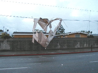
William T. Reid wrote a article for the March-April 1998 edition of Stormtrack.org indicating that a Jan. 1998 ELB event -- which tore part of the roof off the former Lucky (now Albertsons) market on Spring St. just west of Palo Verde Ave. -- was a tornado and "was pretty strong by California-tornado standards."
Mr. Reid lives in CA most of the year...and from May through June is in the midwest as a Tour Director for Tempest Tours (www.tempesttours.com), created by veteran storm chasers like himself, offering the public an opportunity to chase tornados across "Tornado Alley" each year. Mr. Reid's biographical sketch on the firm's website says he's "tracked storms across more than a dozen states since 1991. He is a member of the Texas Severe Storms Association Board of Directors. He acquired a Masters degree in Geography, with emphasis on Climatology, from California State University [CSUN]."
His 1998 article contains many local geographical references, instantly recognizable to LB locals. We requested, and Mr. Reid granted, permission for LBReport.com to republish his piece for our readers.
The Long Beach Tornado of 1998
by Bill Reid.
It will never rank up there with Wichita Falls of 1979, Red Rock of 1991, or Pampa of 1995, but the Long Beach tornado on January 9th, 1998, was pretty strong by California-tornado standards. As is often the case for tornadic activity along the California coast, the storm cell which spawned the twister was relatively unimpressive.
On the 9th, a slightly negative-tilt trough moved through Southern California. (Troughs tilted with a negative orientation, i.e., northwest to southeast on a weather map, generally promote greater air-mass-lifting than those with positive orientations.)
The 2 p.m. forecast discussion out of NWS Oxnard noted: "weak front is now pushing through the Southern California coastal waters and it is moving at a pretty good clip...pilot reports down near San Diego indicate a 140-knot jet...so that explains the frontal movement and the bowing evident on the satellite picture...mostly light rain ahead and with the front...along with areas of moderate/heavy rain...a voracity max is swinging down behind the front...and will move through tonight."
The 2:30 p.m. discussion out of the San Diego NWS office noted thunder earlier that morning at Pacific Beach, and "a funnel cloud near Long Beach."
A special weather observation at Long Beach Airport (LGB) at 1:45 p.m. was rather un-noteworthy. The base of an overcast layer was at 3400 feet, the visibility was 10 miles, and the wind was 140 at 8 knots.
The normal hourly observation made only 11 minutes later (at 1:56 p.m. PST) indicated heavy rain, one-mile visibility, and a wind of 160 at 6 knots. The overcast layer was at 2800 feet, with broken clouds at 1800 feet, and the rain had begun at 1:52 p.m.
Another special observation, made at 2:18 p.m., revealed that the rain had ended at 2:15 p.m., 0.41 inches had fallen, visibility was 10 miles again, and the wind was from the south-southwest at 7 knots. Temperature and dew point were both 16C, or 61F.
During this time, a tornado was uprooting trees, destroying roofs and signs, and forcing people to run for safety, less than three miles away!
By 2:25 p.m. the NWS in Oxnard had issued a tornado warning for "southwestern Los Angeles County," as "a spotter at Long Beach reported a tornado in Long Beach at Spring and Palos Verdes streets near Cubberley Elementary School." (Cubberley School is about a half mile northeast of Palo Verde Avenue and Spring Street.)
The storm moved northeast and the NWS continued the warning, especially for La Habra Heights at 2:40 p.m. and for the 57 and 60 Freeway interchange area in Diamond Bar at 2:55 p.m. At 3:10 p.m. the storm had dissipated and the warning was canceled. Though the official observations from Long Beach did not mention a tornado while it was in progress, the METAR observation taken at Long Beach at 2:56 p.m. remarked: "tower reported tornado two to three miles east of field at 2 p.m. moving northeast and dissipated."
At 2:58 p.m. the observer at Los Alamitos (SLI) reported "CB NW-NE and OVHD-S-W moving NE. This station, about five miles east of Long Beach Airport, was also very close to the storm's path. Wind at Los Alamitos was 160 at 13 knots at 1:23 p.m., and 150 at 8 knots at 1:55 p.m., about the time the tornado was forming. None of the reports from SLI indicated anything unusual, and no rain was reported except for a light rain shower at 2:58 p.m.
News video of the storm damage showed a good chunk of a Lucky supermarket's roof torn off and numerous trees blown down. (The Lucky is at Spring and Palo Verde.) An amateur videographer at Cubberley School caught the tornado for a few seconds. His video showed an intense and tight rotation very close to the school.
The Weather Channel showed the tornado as a waterspout moving onshore near Long Beach Harbor, with a strong and tight circulation on the water and a spectacular funnel cloud. Apparently this video was taken by a news stations' "tower-cam."
The damage path (as investigated by the NWS) was less than two-miles long, but approximately four miles separate the "waterspout/tornado" near the harbor and the southwest end of the NWS' damage path (see below).
I spoke with David Danielson of the National Weather Service in Oxnard about two weeks after the tornado. He has investigated the event, and he shared some of his findings with me. The Long Beach tornado tracked parallel to the Los Coyotes Diagonal and "skipped intermittently." It took off a 60-foot by 60-foot portion of the Lucky roof, and would be rated F0 to F1 on the Fujita scale, according to Danielson.
The average path width was about 20 yards wide, and was about 30 yards wide at the Lucky market. Touchdowns were confirmed near Barbanell Street and Los Coyotes, north of CSU Long Beach, and as far northeast as Cubberley Elementary on Monogram.
The tornado occurred from 2:00 p.m. to 2:10 p.m. PST. There were no injuries, according to the Fire Department and Police Department, but media reported an injury to a clerk at Lucky due to flying glass. At Cubberley Elementary, a "Mr. Bogel" moved two bus loads of kids into an auditorium when he saw the tornado approach. It is amazing that the tornado caused no major problems on the San Diego Freeway and at Millikan High School.
On the meteorological side of things, no thunder or hail was reported with the storm. At 1:43 p.m. the storm's top was at 29,000 feet, and at 2:03 p.m. it had collapsed to only 24,000 feet.
At 1:58 p.m. the Santa Ana Doppler radar beam intersected the storm at an elevation of 4970 feet, and the archived reflectivity "doesn't look that awesome," according to Danielson. Rich Thompson of the Storm Prediction Center in Norman, Oklahoma, did not include Southern California for thunder in his Day One Severe Weather Outlook (issued at 12:30 p.m. for the remainder of January 9th).
Thompson reported that the Long Beach storm was "quite small on radar, and would have been difficult to do much with" (in other words, little large-scale storm rotation was evident). He noted that the "thunder line" means an average point-probability of thunder of 10% or greater within the bounded area, so "this may have rightfully been a no thunder forecast even with the tornado!"
Thompson also said that "near-surface flow around Santa Catalina Island may have played some role in improving low-level shear." I might add that the Palos Verdes Hills may have been important, too, in augmenting wind convergence beneath the storm.
Several storm systems have spawned tornadoes, waterspouts and funnel clouds in coastal Southern California this winter season, the Long Beach tornado just one of many. Now if we could only get a big thunderstorm attached to one of our tornadoes...maybe some screaming 15-knot inflow, too.
[end Reid text]
So...why didn't LBReport.com cover the 1998 tornado at the time? We launched in August 2000...and provided detailed on-scene coverage of the Dec. 29, 2004 ELB tornado. Some excerpts:
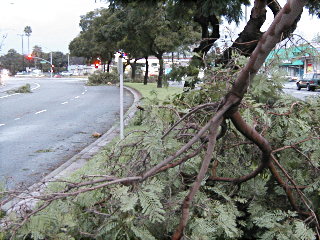
 (January 6, 2005) -- LBReport.com has confirmed with the National Weather Service that the fierce windstorm that struck parts of ELB (esp. Woodruff Ave. near Wardlow Rd., extending on a diagonal from Spring St. to Conant St.) shortly after midnight on December 29 really was a tornado.
 Dan Keeton, meteorologist in charge of the National Weather Service Oxnard (our area) office told LBReport.com that he personally came to Long Beach to visit the damaged areas within twelve hours of the event...and he used the digital photos posted by LBReport.com find the areas affected.
Details from Mr. Keeton follow:
 "What we look for is evidence of rotation, and when I came to the area of Long Beach that was affected, I observed trees facing one way in one place, and then trees facing another way some distance away. That shows rotation."
 "Other evidence included some bent TV antennas and minor shingle damage, and there was also a characteristic spottiness to the damage."
 "In talking to people, I also received unprompted witness accounts with tornado type characteristics, describing things like items hitting the outside of the house."
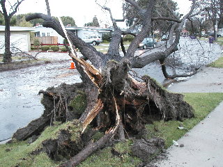 "Taken together, we believe it was an Category F0 tornado. That's the lowest category. My unscientific estimate is the winds were about 65 m.p.h."
Mr. Keeton added: "We saw a large storm on Doppler Radar moving from Avalon into western Los Angeles County at about 10:30 p.m...and it had some rotation in it and we issued an alert. We had other tornado type damage in Inglewood and Whittier. We had reports of the top a palm tree torn off closer to downtown Long Beach (3900 block E. 5th St.) shortly after 11:00 p.m...followed by the multiple tree damage (in ELB) after midnight.
So were there were one or two tornadoes? "Probably two," Mr. Keeton said.
 Is it accurate to say that a tornado or tornadoes "touched down"?
"When something attached to the ground is damaged, we say a tornado touched down," Mr. Keeton said.
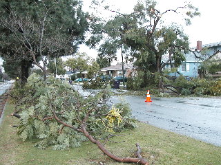
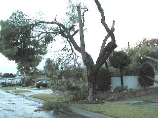
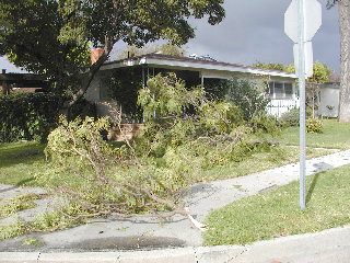
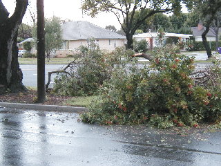 Along Woodruff Ave., south of Wardlow Rd.
 An L.A. TV station shot video of the area just east of Marshall Middle School.
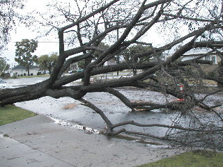
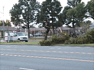
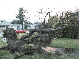
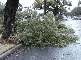 Woodruff Ave. access road, just south of Wardlow Rd.
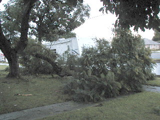
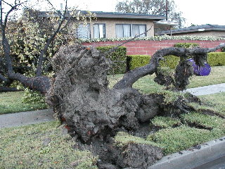
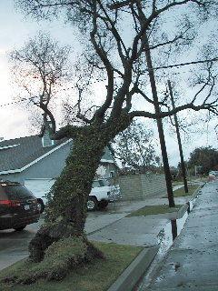 This tree is less than perpendicular...and appears to be heading horizontal. Faust Ave...north of Wardlow Rd.
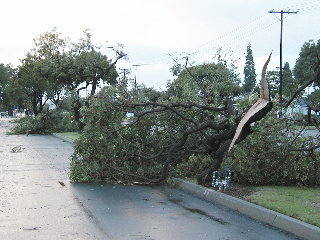
 Fanwood Ave. at Faust.
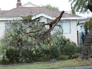
 Likewise on Fanwood Ave.
 Also on Fanwood Ave.
 Wardlow Rd. at Faust
 Wardlow Rd., looking west toward Woodruff Ave.
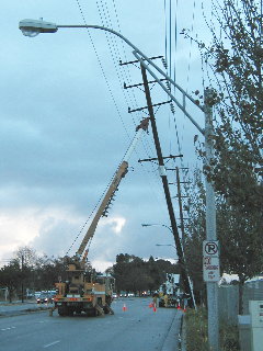 Here's a blackout (or worse) avoided: Edison crews scrambled to stabilize this power pole on Spring St. just east of Bellflower Blvd.
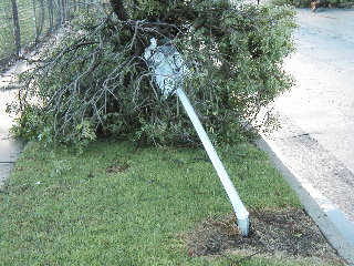 This "no parking sign" bit the dust, knocked over by a tree, east of Marshall Middle School.
Northward near Conant St., Patrick Henry Elementary School also had trees downed.
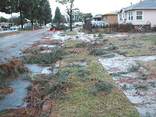
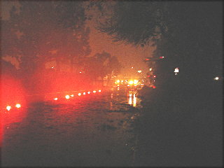 LBReport.com brought our readers the story before dawn...with pictures. At predawn, flares marked off parts of Los Coyotes Diagonal west of Bellflower Blvd., blocked by numerous tree branches.
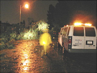 LBFD crews were out in force, here along Wardlow Rd.
 LBReport.com reader P. Harvey captured this at Monlaco Rd. at Senasac Ave. and told us in an accompanying email:
"I was up at 12:30 a.m. and would say it was more like a mini-tornado...[T]here was a loud hissing sound, the air was suddenly grey and the rain became tiny droplets flying horizontally."
[end LBReport.com news review coverage]
On January 24, 2008, the National Weather Service issued a Tornado Watch at 9:17 p.m. In ELB, there was heavy rain, some thunder and lightning...but no twister touched down. The Tornado Watch was downgraded to a Flash Flood Watch at 10:00 p.m.