|
|
 |
 |  |
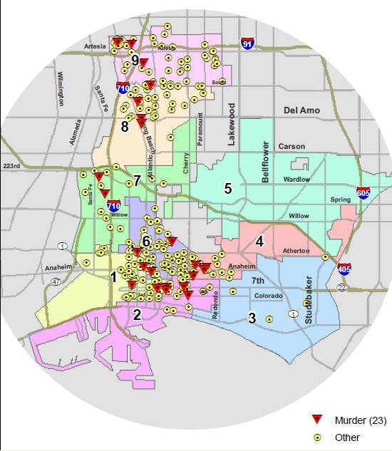
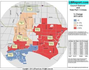
| LBREPORT.com provides below a collection of our detailed reports on crime in Long Beach. The reports below show the geographic dispersion of crime. The information is based on LBPD released crime data but with details independently mapped and derived by GIS mapping expert Jennifer Gomez for LBREPORT.com.
Until early 2004, City Hall routinely reported crime data by Council district, but ended the practice entering the 2004 election cycle. Digital technology now enables us to resume providing the public with information that City Hall no longer does...plus added details.
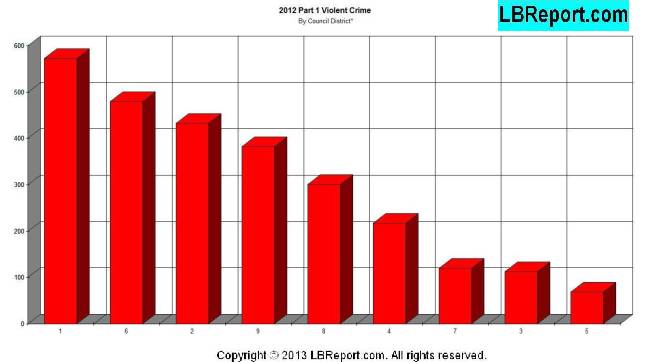
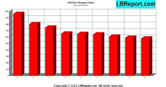
Council district lines are political and thus to some extent inherently arbitrary, but inasmuch as Councilmembers routinely seek credit for what takes place in their districts, we think the public has a right to know crime conditions in the areas that Council incumbents were elected to represent. In our view, the maps and data are analogous to an ultrasound or an X-ray. They're not perfectly sharp images but they do provide a useful tool for analysis and interpretation. Regarding data in table form: not all areas within a Council district experience crime at the average rate. For example, the western portion of the 4th Council district (near Cherry Ave.) had significantly more violent crimes than the eastern end (Los Altos). Some underlying data is less than clear. In a small percentage of cases, shootings (identified only within the "100" block of a street) fall on a street that borders two two Council districts (one district on one side of the street, another on the other side). Our mapping is as precise as we can make it, but for data tables the few shootings on streets bordering two Council districts are allocated half to one district and half to another. Finally, and very important: every statistic represents a real person. These are not just numbers; they are people. And beyond the victims directly involved, many other people living and working in crime-impacted areas endure streets blocked by crime scene tape, helicopters whirring overhead and sometimes the inability to enter or leave one's neighborhood as police investigate crime scenes or search for perpetrators. Residents of an entire neighborhood have suffer impacts to their quality of life although they're not counted in conventional crime statistics.
Contact us: mail@LBReport.com |
   You can love where you bank! Credit unions are the only democratically controlled financial institutions in the U.S. In 1935, LBS Financial Credit Union opened its doors to Long Beach educators...and today LBS Financial serves ANYONE who lives or works in the local community. Click here for further information.         Hardwood Floor Specialists Call (562) 422-2800 or (714) 836-7050  |
Contact us: mail@LBReport.com